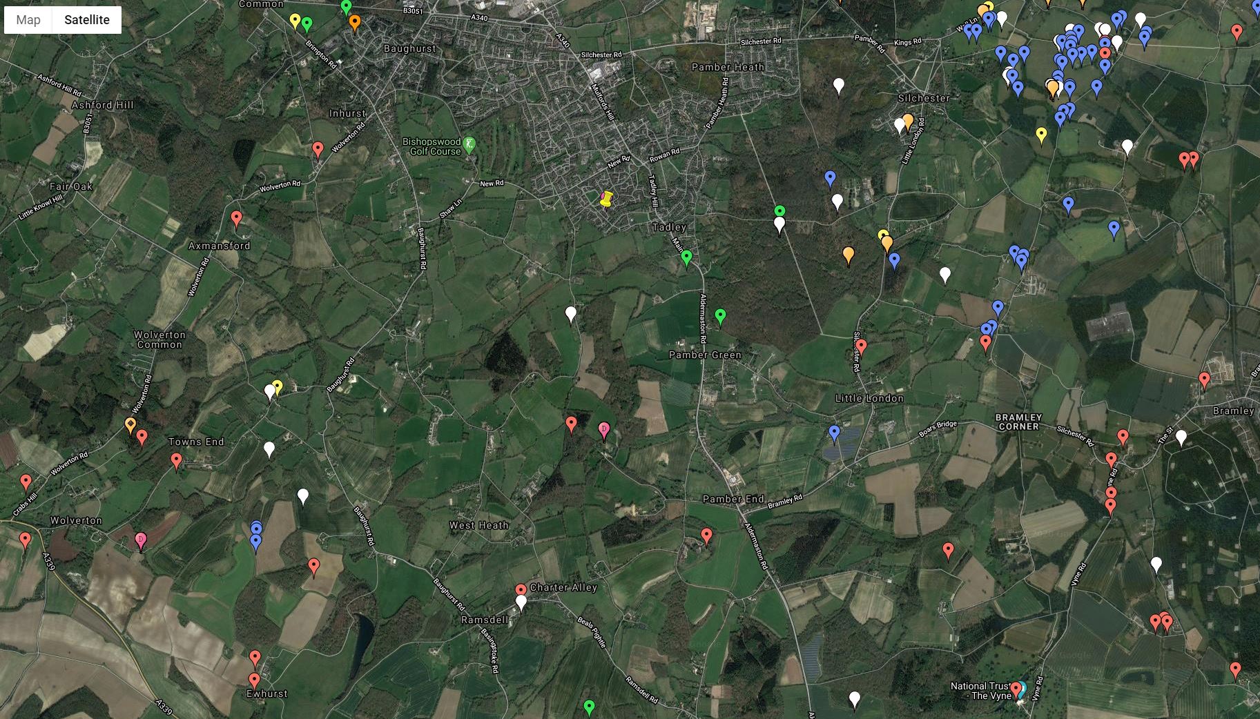
Bronze age Strip Found in Tadley (see British Museum)
DescriptionGold strip. A single fragment of beaten sheet metal of rectangular shape with one surface decorated with 10 finely incised and very straight grooves. The other surface is plain and relatively flat and smooth, with the grooves visible in places but not fully penetrating through from the opposite side. The surviving terminal has a centrally-placed perforation, c.1.5mm from the terminal end. This end has also been bent or folded over, with the decorated side facing uppermost. The opposite end has been broken off. The undecorated surface carries some minor cracks from the distortion of the band/ribbon. The intact terminal end appears to have been slightly ‘crimped’.
The perforation has been pushed through from the undecorated side. This may be a product of the perforation technique and does not necessarily mean that it was fastened in this way. A small mound of gold created around the perforation, viewed under a microscope, appears to have been slightly flattened. It is therefore possible that it was secured by a fastening pushed through in the opposite direction. It may have served as an ornament that was worn or a mount applied to another object.
FindspotFound/Acquired: Tadley
Curator’s commentsFound on the 9th of March 2013 in the course of metal detecting. No further details regarding the context of the find.
Metal composition (Non-destructive X-ray fluorescence analysis of the surface by Department of Conservation and Scientific Research for the Treasure process at three points on the surface of a grooved and perforated metal sheet fragment): Gold: c.82-84%, a silver: c.13-15%, with approximately 2% copper.
Medieval
Site 3. Medieval: 12th Century found : at 51.326451, -1.075692 (SU 645 590).
Site 7. Medieval: 12th Century found : at 5155.318755, -1.127505 (SU 609 581).
Site 10. Medieval: Place called Bramley and known as Brumelai mentioned in the Domesday Book : at 51.326394, -1.068517 (SU 65 59) Note site co-ordinate is a four figure NGR.
Site 16. Medieval: Site of Medieval Rubbish Pit : at 51.262718, -1.089869 (SU 636 519).
Site 19. Medieval: Place called Thatcham and known as Taceham mentioned in the Domesday Book : at 51.399746, -1.268277 (SU 51 67) Note site co-ordinate is a four figure NGR
Site 25. Medieval: Place called Mapledurwell and known as Mapledrewelle mentioned in the Domesday Book : at 51.254120, -1.026989 (SU 68 51) Note site co-ordinate is a four figure NGR.
Site 28. Medieval: Site of Medieval Church : at 51.264516, -1.089834 (SU 636 521).
Site 32. Medieval: Site of timber-framed : at 51.261808, -1.088454 (SU 637 518).
Site 48. Medieval: Site of Medieval Burial Ground : at 51.329937, -1.181835 (SU 571 593).
Site 66. Medieval: Place called Ecchinswell and known as Eceleswelle mentioned in the Domesday Book : at 51.327907, -1.283773 (SU 50 59) Note site co-ordinate is a four figure NGR.
Site 70. Medieval: Moated site and associated fishponds : at 51.348052, -1.066929 (SU 6508 6141).
Site 61. Medieval: Moated site and three fishponds at Ufton Nervet : at 51.401133, -1.093594 (SU 6315 6729).
Site 60. Medieval: Place called Ewhurst and known as Werste mentioned in the Domesday Book : at 51.300278, -1.183797 (SU 57 56) Note site co-ordinate is a four figure NGR.
Site 63. Medieval: Market and Fair sited at this town/village : at 51.401490, -1.259624 (SU 516 672).
Site 76. Medieval: Place called Hartley wespall and known as Harlei/Herlei mentioned in the Domesday Book : at 51.316933, -1.011312 (SU 69 58) Note site co-ordinate is a four figure NGR.
Site 123. Medieval: Site of Medieval Enclosure : at 51.308718, -1.235294 (SU 534 569).
Site 125. Medieval: Site of Medieval Village : at 51.264314, -1.184434 (SU 570 520).
Site 151. Medieval: Site of whipping post : at 51.274052, -1.045204 (SU 667 532).
Site 152. Medieval: Site of Medieval Village : at 51.316411, -1.176336 (SU 575 578).
Site 153. Medieval: Place called Malshanger and known as Gerlei mentioned in the Domesday Book : at 51.264413, -1.198764 (SU 56 52) Note site co-ordinate is a four figure NGR.
Site 155. Medieval: Site of Moat : at 51.315219, -1.021392 (SU 683 578).
Site 165. Medieval: Deserted Medieval Village – Medieval Village Site : at 51.348338, -1.003456 (SU 695 615).
Site 141. Medieval: Site of 11th Century Church : at 51.295194, -1.229782 (SU 538 554).
Site 142. Medieval: Site of Moat : at 51.334926, -1.012360 (SU 689 600).
Site 144. Medieval: Place called Basing, old and known as Basinges mentioned in the Domesday Book : at 51.263345, -1.055459 (SU 66 52) Note site co-ordinate is a four figure NGR.

Record ID: HAMP-F749C7
Object type: FINGER RING
Broad period: MEDIEVAL
County: Hampshire
Workflow stage: Awaiting validation 
A medieval finger-ring with a slender hoop, highly decorated with many facets creating lozenge shaped fields into which crosses have been engraved. Between each faceted lozenge are two vertical bands. The hoop is joined at the bezel by two degenerate dragon’s heads which bear a blue stone (probably a sapphire). The finger-ring is gold and dates to the late thirteenth or early fourteenth century.
Created on: Friday 10th April 2009
Last updated: Thursday 12th September 2013
Spatial data recorded. This findspot is known as ‘Tadley’, grid reference and parish protected.
Read More…
-
Record ID: LVPL-39841E
Object type: CASTING WASTE
Broad period: UNKNOWN
County: Cheshire East
Workflow stage: Awaiting validation
Possible lead alloy object. The object is uneven and may simply be casting waste. The object has an off-white to grey patina and is lightly pitted.
Created on: Thursday 22nd March 2018
Last updated: Wednesday 25th April 2018
Spatial data recorded. This findspot is known as ‘Tadley’, grid reference and parish protected.
Record ID: HAMP-F02576
Object type: RING
Broad period: BRONZE AGE
County: Hampshire
Workflow stage: Awaiting validation
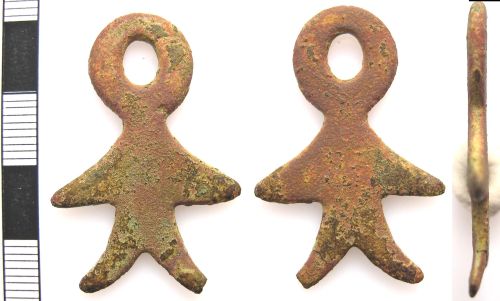
A copper alloy annular ring of uncertain date, from the Late Bronze Age to the post-medieval period (c. 1000 BC – AD 1900). Much of the original patina is missing but where it survives it is a green-brown colour, smooth and shiny. The ring measures 60.2mm in diameter (internal 45.6mm) with an area of abrasion to the inside edge c.8mm in width, possibly caused by suspension. It is max.4.6mm thick. In cross-section the ring is triangular, with a point at the outside edge and a short (and slightly convex) edge to the inside surface of the ring. It weighs 30.04g. The large diameter of t… Spatial data recorded. This findspot is known as ‘Tadley’, grid reference and parish protected.
Record ID: HAMP-9E612E
Object type: COIN
Broad period: IRON AGE
County: Hampshire
Workflow stage: Awaiting validation
An Iron Age uninscribed gold quarter stater, similar to the ‘Three Wheels’ type of the east Wiltshire grouping (ABC nos.2093, 2095) dating to c.50-35 BC (Rudd 2010; 107) and the ‘Tadley Wheel’ type struck by Rudd’s suggested Belgae group (ABC 806) anddating to c.65-40 BC (Rudd 2010; 57). The coin measures 9.7mm in diameter and weighs 1.15g. Obverse: Possible abstract head of Apollo facing right, wheel in front Reverse: Horse going left with pellets at knee joints, wheel above and below
Created on: Tuesday 10th February 2015
Last updated: Wednesday 11th February 2015
Spatial data recorded. This findspot is known as ‘Andover’, grid reference and parish protected.
Record ID: HAMP-6157F2
Object type: HARNESS FITTING
Broad period: EARLY MEDIEVAL
County: Hampshire
Workflow stage: Awaiting validation
An incomplete late early-medieval (1000-1100) Anglo-Scandinavian copper alloy bit link from horse harness, consisting of a central (possibly zoomorphic) boss and a short arm to either side, terminating in a loop (both of which are broken and incomplete though old worn breaks). The central boss is lozenge-shaped, domed and hollow to the reverse. It has moulded decoration, now worn, but apparently in the form of two back-to-back animal heads, each triangular in shape with the inside of the ears defined by a triangular depression. One loop appears larger than the other and has knobbed …
Created on: Friday 14th November 2014
Last updated: Sunday 10th January 2016
Spatial data recorded. This findspot is known as ‘Tadley’, grid reference and parish protected.
Record ID: HAMP-609733
Object type: SOCKETED AXEHEAD
Broad period: BRONZE AGE
County: Hampshire
Workflow stage: Published
A fragment of Late Bronze Age (1150-800 BC) socketed axehead, consisting of the cutting and lower body only and broken at start of the socket. The fragment is very worn and much of the original mid-green smooth patina is missing. At the break, the socket measures 26.47×15.26mm (internal 16.34×7.48mm). The sides expand gently to the curved cutting edge, which measures 35.95×2.79mm. It measures 43.02mm in length, 35.95mm in max.width, 15.26mm in max.thickness and weighs 77.32g.
Created on: Friday 14th November 2014
Last updated: Thursday 27th November 2014
Spatial data recorded. This findspot is known as ‘Tadley’, grid reference and parish protected.
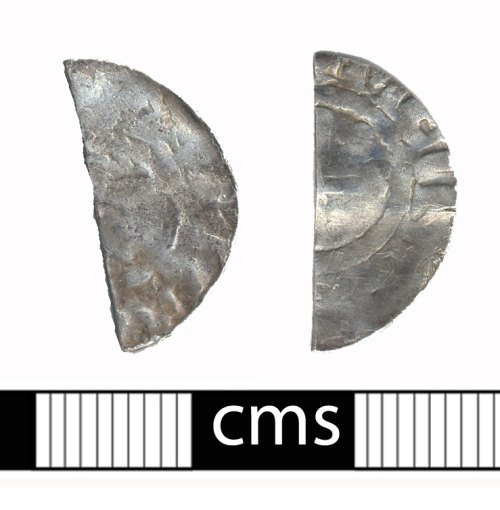
Record ID: BERK-BF8985
Object type: COIN
Broad period: MEDIEVAL
County: Hampshire
Workflow stage: Awaiting validation
A very worn cut-half silver penny of either Richard I (AD 1189-1199) or John (AD1199-1216), struck by the moneyer Meinir in Canterbury. The obverse is too worn to be able to identify with certainty under which king this coin was struck, but it may well be Richard rather than John due to features of the reverse lettering; probably Class II, struck in AD 1189-1190. North N965.
Created on: Wednesday 17th August 2011
Last updated: Thursday 18th August 2011
Spatial data recorded. This findspot is known as ‘Tadley area’, grid reference and parish protected.
Record ID: BERK-C6F0A4
Object type: THIMBLE
Broad period: POST MEDIEVAL
County: Hampshire
Workflow stage: Awaiting validation
A Post Medieval copper alloy thimble made from hammered sheeting (16th century). The thimble has a rounded crown with a row of small circular, drilled pits that spiral downwards from the crown to the base. The crown is worn. The bottom of the thimble has a single engraved line running around the base. The base is slightly damaged in some places. Dark green patina. Dimensions: length 18.37mm; diameter at top 15.37mm; diameter at bottom 21.27mm; weight 8.30g.
Created on: Thursday 17th November 2005
Last updated: Thursday 24th February 2011
Spatial data recorded. This findspot is known as ‘Tadley’, grid reference and parish protected.
Record ID: BERK-AA9F76
Object type: MARKER
Broad period: POST MEDIEVAL
County: Hampshire
Workflow stage: Awaiting validation
A Post Medieval copper alloy chain marker (?1650-present). The marker has been cast with a perforated circular terminal which then expands to form two triangular ‘wings’ before terminating in two curving pointed projections. It is designed to fit into a chain link and when twisted through 90 degrees within the chain link it cannot easily fall out. Rough brown/green patina. Dimensions: length: 38.46mm; width: 25.62mm; thickness: 2.54mm; weight: 7.14g.
Created on: Wednesday 28th September 2005
Last updated: Thursday 24th February 2011
Spatial data recorded. This findspot is known as ‘Tadley’, grid reference and parish protected.
Record ID: BERK-AA9571
Object type: ROTARY KEY
Broad period: MEDIEVAL
County: Hampshire
Workflow stage: Awaiting validation
A Medieval copper alloy casket key (late 12th – late 14th century). A small key with circular bow, solid shank with oval cross-section and simple bit with symmetrical triangular clefts. The key is bent so the end of the shaft and the bow curves away from the bit end. Pale green rough patina. Dimensions: length: 42.63mm; width: 15.06mm; thickness: 2.89mm; weight: 7.52g. Egan, G The Medieval Household Daily Living c. 1150-c. 1450 Medieval Finds from Excavations in London: 6 London [pages: 111-112 ] Created on: Wednesday 28th September 2005
Last updated: Thursday 24th February 2011
Spatial data recorded. This findspot is known as ‘Tadley’, grid reference and parish protected.
Record ID: BERK-6A6B07
Object type: BUCKLE
Broad period: POST MEDIEVAL
County: Hampshire
Workflow stage: Awaiting validation
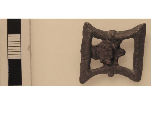
A copper alloy buckle frame. The buckle is plain sub-rectangular with a cross bar. The long sides of the frame are curved inwards to create a waisted effect. Part of the iron tongues is present on the cross bar. There are two small projections, one at each side of the buckle, located at the junction between the buckle frame and the cross bar. It is similar to one in Cuddeford “Identifying buckles” dated to the 16th-17th centuries.
Created on: Thursday 15th July 2004
Last updated: Thursday 24th February 2011
Spatial data recorded. This findspot is known as ‘Tadley’, grid reference and parish protected.
Record ID: BERK-6A5F76
Object type: BUTTON
Broad period: MEDIEVAL
County: Hampshire
Workflow stage: Awaiting validation
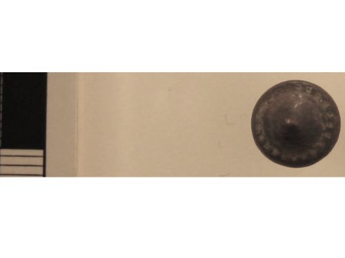
Small conical copper alloy button with loop on reverse. The button has a conical head with a ring of punched dots forming a border midway down the head. It is constructed of two pieces of stamped sheet metal soldered together, with a separate shank that passes through a central hole on the reverse. It is similar to one illustrated in Egan and Pritchard’s “Dress Accessories” within the date range 1150-1450.
Created on: Thursday 15th July 2004
Last updated: Thursday 24th February 2011
Spatial data recorded. This findspot is known as ‘Tadley’, grid reference and parish protected.
Record ID: BERK-6A5247
Object type: BRACELET
Broad period: ROMAN
County: Hampshire
Workflow stage: Awaiting validation
A fragment of a copper alloy twisted wire, possibly a fragment of an armlet. It is constructed from two strands of wire twisted together and then pinched together at each end. Both ends of the fragment terminate with a thinner piece of wire wrapped horizontally around the object ?to form a slip knot to alter the diameter of the armlet, or possibly as decoration. From the centre of the smaller twists of wire projects a short length of the thinner wire. There are similar examples illustrated in Crummy that are dated c.320-450AD (1983:38-39 fig.41).
Created on: Thursday 15th July 2004
Last updated: Thursday 24th February 2011
Spatial data recorded. This findspot is known as ‘Tadley’, grid reference and parish protected -


Distribution map of archaeological sites and metal detecting finds and findspots in the area of 51.355629 -1.089394. Generated by the ARCHI UK database at https://www.archiuk.com/search.
SU 60 61: List of Site Locations From Your Search of ARCHI (at 0:44 GMT on Tuesday)
Roman
Site 1. Roman: Site of Roman pit – Site of Roman cropmark : at 51.355629, -1.089394 (SU 63505 62233).
Site 2. Roman: Site of Roman road : at 51.286540, -1.282983 (SU 501 544).
Site 21. Roman: Site of Roman Settlement – Site of Romano-British settlement – Site of Romano-British settlement – Site of Romano-British settlement : at 51.259852, -1.068429 (SU 651 516).
Site 26. Roman: Aerial Photo shows Single circle – Neolithic pottery : at 51.406018, -1.133034 (SU 604 678).
Site 27. Roman: Aerial Photo shows Small circle : at 51.429144, -1.099513 (SU 627 704).
Site 33. Roman: Roman Site. Record Requiring further analysis. : at 51.268133, -1.115879 (SU 61778 52480).
Site 54. Roman: Aerial Photo shows Single circle : at 51.428770, -1.052053 (SU 660 704).
Site 55. Roman: Aerial Photo shows Incomplete circle : at 51.425872, -1.027661 (SU 677 701).
Site 35. Roman: Aerial Photo shows Single circle : at 51.396296, -1.156216 (SU 588 667).
Site 36. Roman: Site of Roman Enclosure : at 51.267179, -1.208750 (SU 553 523).
Site 40. Roman: Site of Roman Villa : at 51.416742, -1.124203 (SU 61 69) Note site co-ordinate is a four figure NGR.
Site 42. Roman: Aerial Photo shows 2 conjoined subcircular enclosures : at 51.428303, -0.995965 (SU 699 704).
Site 49. Roman: Aerial Photo shows Possible Rectangular Enclosure : at 51.413793, -1.091187 (SU 633 687).
Site 50. Bronze Age: Site of Bowl Barrow : at 51.283195, -1.184099 (SU 570 541).
Site 51. Roman: Site of Roman road : at 51.334677, -1.092752 (SU 633 599).
Site 62. Roman: Site of possible Roman Settlement : at 51.389239, -1.270457 (SU 5086 6583).
Site 64. Roman: Aerial Photo shows Triple-ditched enclosure : at 51.417769, -1.026395 (SU 678 692).
Site 65. Roman: Site of Roman field boundaries – Site of Roman cropmark : at 51.363212, -1.125167 (SU 61004 63046).
Site 68. Roman: Site of Roman Pottery Kiln – Site of Roman amphitheatre – Site of Roman kiln – Site of Roman pottery kiln – Site of Roman kiln sites – Site of Roman pottery kiln – Site of Roman kiln sites : at 51.358828, -1.076476 (SU 6440 6260).
Site 73. Roman: Aerial Photo shows Irregular linear features : at 51.415000, -1.017826 (SU 684 689).
Site 75. Roman: Aerial Photo shows Subrectangular enclosure – Iron age double-ditched rectangular enclosure to have been in use during the first and second centuries AD. A single Saxon Grubenhaus : at 51.416667, -1.114139 (SU 617 690).
Site 80. Roman: Site of Roman town – Site of Roman temple – Site of Roman temple : at 51.355646, -1.083577 (SU 6391 6224).
Site 81. Roman: Site of Roman Pottery Kiln : at 51.359003, -1.075898 (SU 6444 6262).
Site 159. Roman: Site of Roman burial : at 51.280084, -1.126804 (SU 610 538).
Site 160. Roman: Findspot of Roman pottery : at 51.269604, -1.051030 (SU 663 527).
Site 164. Roman: Aerial Photo shows Road : at 51.431852, -1.100898 (SU 626 707).
Site 92. Roman: Site – Site of Roman Villa – tesserae found – coin of Alexander Severus found : at 51.298379, -1.169487 (SU 580 558).
Site 93. Roman: Follis of Constantine I (Roman Coin) found : at 51.377674, -1.071787 (SU 647 647).
Site 96. Roman: Aerial Photo shows Extensive complex – D-shaped enclosure : at 51.419697, -0.999029 (SU 6970 6944).
Site 109. Roman: Site of Roman cropmark – Site of Roman settlement : at 51.432823, -1.098578 (SU 6276 7081).
Site 112. Roman: Site of Roman building – mortar found – tesserae found – samian ware found : at 51.288214, -1.207815 (SU 5534 5464).
Site 113. Roman: Site of Roman road : at 51.378708, -1.089008 (SU 635 648).
Site 116. Roman: Site : at 51.411023, -1.081896 (SU 6395 6840).
Site 121. Roman: Much Roman pottery found – Site of Roman occupation : at 51.351860, -1.082361 (SU 6400 6182).
Site 143. Roman: Site of Roman road : at 51.321816, -1.177674 (SU 574 584).
Site 124. Roman: Aerial Photo shows Incomplete circle : at 51.427658, -1.026185 (SU 678 703).
Site 129. Roman: Site of Roman road : at 51.299145, -1.126442 (SU 6100 5592).
Site 130. Roman: Site of Roman Building – flue tiles found – Site of Roman building – flue tiles found – Site of Roman building – flue tiles found : at 51.356509, -1.256041 (SU 519 622).
Site 135. Roman: Site of Roman road : at 51.281882, -1.126770 (SU 610 540).
Site 132. Roman: Findspot of Roman coin(s) : at 51.357086, -1.083692 (SU 6390 6240).
Site 138. Roman: Site of Roman road : at 51.316527, -1.071586 (SU 648 579).
Site 145. Roman: Aisled Building – Engraved Gemstone found (intaglio) : at 51.344709, -1.111219 (SU 62 61) Note site co-ordinate is a four figure NGR.
Site 89. Roman: Flue tiles found – tessarae found : at 51.287432, -1.032021 (SU 676 547).
Site 173. Roman: Site of Roman Settlement : at 51.256198, -1.061337 (SU 656 512).
Site 174. Roman: Site : at 51.411928, -1.082597 (SU 639 685).
Mesolithic
Site 38. Mesolithic: Scrapers found : at 51.260229, -1.117148 (SU 617 516).
Site 46. Mesolithic: Flint Tranchet Axe/Adze found : at 51.255519, -1.213249 (SU 550 510).
Site 4. Mesolithic: Scraper found : at 51.303489, -1.261202 (SU 516 563).
Site 14. Mesolithic: Flint Microlith, Flint Blade found : at 51.396666, -1.209393 (SU 551 667).
Site 56. Mesolithic: Flint Tranchet Axe/Adze found : at 51.407193, -1.052499 (SU 660 680)
Bronze Age
Site 5. Bronze Age: Bronze spearhead found : at 51.366908, -1.074878 (SU 645 635).
Site 11. Bronze Age: Site : at 51.334914, -1.010925 (SU 69 60) Note site co-ordinate is a four figure NGR.
Site 13. Bronze Age: Site of Bronze Age settlement : at 51.414838, -1.237839 (SU 5310 6870).
Site 15. Bronze Age: Site of Ring Ditch : at 51.381395, -1.172440 (SU 5769 6503).
Site 17. Bronze Age: Socketed axe found : at 51.423491, -1.066545 (SU 650 698).
Site 18. Bronze Age: Site of Bowl barrow : at 51.285540, -1.266795 (SU 5123 5430).
Site 24. Bronze Age: Palstave found : at 51.353199, -1.258823 (SU 5171 6183).
Site 31. Bronze Age: Site of Bowl barrows : at 51.295713, -1.186889 (SU 5679 5549).
Site 99. Bronze Age: Bronze Age Site. Record Requiring further analysis. : at 51.274647, -1.121173 (SU 614 532).
Site 102. Bronze Age: Site of Bowl Barrow : at 51.259839, -1.187379 (SU 568 515).
Iron Age
Site 6. Iron Age: Site – Site of Iron Age urn : at 51.255756, -1.120100 (SU 615 511).
Site 8. Iron Age: Industrial Site : at 51.263901, -1.127111 (SU 610 520).
Site 22. Iron Age: Hillfort with a single defensive bank – Site of Iron Age Hill Fort : at 51.362625, -1.102254 (SU 626 630).
Ancient Site
Site 9. Description: Site of Barrows (2) (sites of) : at 51.386165, -1.088142 (SU 6355 6563).
Site 12. Ancient: Site of Rectilinear Enclosure : at 51.430909, -1.095163 (SU 630 706).
Site 20. Ancient: Site of enclosure : at 51.430975, -1.103793 (SU 624 706).
Site 23. Ancient: Site of Earthwork : at 51.359407, -1.093125 (SU 6324 6265).
Site 29. Ancient: Site of Ancient Enclosure : at 51.288271, -1.139555 (SU 601 547).
Site 37. Ancient: Site of Ancient camp : at 51.376843, -1.080424 (SU 641 646).
Post Medieval
Site 30. Post Medieval: Site of Friends Burial Ground : at 51.324623, -1.193411 (SU 563 587).
Site 34. Post Medieval: Site of Manor House : at 51.319557, -1.002645 (SU 696 583).
Site 41. Post Medieval: Site of Almshouse : at 51.262673, -1.084137 (SU 640 519).
Site 43. Post-Medieval: Site of Watermill : at 51.435307, -1.205850 (SU 553 710).
Site 47. Post-Medieval: Site of Watermill : at 51.327901, -1.032605 (SU 675 592).
Site 53. Post Medieval: Site of Post-Medieval Drinking Fountain : at 51.262707, -1.088436 (SU 637 519).
Site 72. Post Medieval: Site of chalk pit : at 51.256118, -1.120523 (SU 6147 5114).
Site 74. Post Medieval: Site of Pond-Bay : at 51.375966, -1.083316 (SU 639 645).
Neolithic
Site 39. Neolithic: Burnt flints found : at 51.287858, -1.208395 (SU 553 546).
Tithe Map
Site 44. Tithe Map Data: Location(s) of bridges and footpath and/or bridleway are marked on the old Up Nately [Southampton (hampshire) (Hampshire)] Tithe Map. : at 51.262990, -1.012469 (SU 69 52) Note site co-ordinate is a four figure NGR.
Site 52. Tithe Map Data: Location(s) of railway, bridges and pound are marked on the old Grazely [Grazeley] [tithing in the parish of Sulhamstead Abbots] [Berkshire] Tithe Map. : at 51.388856, -1.009763 (SU 69 66) Note site co-ordinate is a four figure NGR.
Site 59. Tithe Map Data: Location(s) of gardens, footpath and/or bridleway, field names, arable and bridges are marked on the old Mortimer [Berkshire] Tithe Map. : at 51.371346, -1.067605 (SU 65 64) Note site co-ordinate is a four figure NGR.
.
Site 57. Neolithic: Flint axe found : at 51.429715, -1.057787 (SU 656 705).
Site 77. Neolithic: Burnt flint found : at 51.280258, -1.125940 (SU 6106 5382).
Site 58. Iron Age: Iron Age Site. Record Requiring further analysis. : at 51.299145, -1.126442 (SU 6100 5592).
Site 71. Iron Age: Site of Hill Fort – Site of Celtic field system – Site of hill fort : at 51.303525, -1.266939 (SU 512 563).
Site 78. Post Medieval: Site of Water Mill : at 51.319618, -1.252333 (SU 522 581).
Site 84. Mesolithic: Scrapers found : at 51.315901, -1.233740 (SU 535 577).
Site 85. Bronze Age: Site of Ring Ditch : at 51.307031, -1.252537 (SU 522 567).
Site 82. Bronze Age: Site of Bowl barrow : at 51.289829, -1.248228 (SU 5252 5479).
Site 86. Bronze Age: Spearhead found : at 51.392371, -1.239650 (SU 530 662).
Site 94. Bronze Age: Site of Bowl Barrows : at 51.255884, -1.137293 (SU 603 511).
Site 83. Iron Age: Site of Iron Age Fort : at 51.320768, -1.039930 (SU 670 584).
Site 87. Post Medieval: Site of Civil War battery : at 51.273349, -1.069589 (SU 650 531).
Site 88. Historic: Industrial Site : at 51.381294, -1.196726 (SU 560 650).
Site 90. Post Medieval: Site of Brickwork : at 51.314428, -1.150544 (SU 593 576).
Site 97. Post Medieval: Site of Manor House : at 51.334926, -1.012360 (SU 689 600).
Prehistoric
Site 91. Prehistoric: Site of Prehistoric pit : at 51.413178, -1.128585 (SU 6070 6860).
Site 95. Neolithic: Mortlake Ware found : at 51.427148, -1.029720 (SU 67555 70240).
Site 98. Tithe Map Data: Location(s) of parkland are marked on the old Wasing [Berkshire] Tithe Map. : at 51.372204, -1.182519 (SU 57 64) Note site co-ordinate is a four figure NGR.
Site 100. Saxon: Site of Saxon Burial : at 51.281531, -1.080895 (SU 642 540).
Site 101. Roman: Aerial Photo shows Complex of rectangular enclosures and linear features : at 51.419331, -1.109773 (SU 620 693).
Site 103. Post-Medieval: Site of Watermill : at 51.273223, -1.053823 (SU 661 531).
Site 105. Bronze Age: Site of Bronze Age cropmark – Site of Bronze Age round barrow : at 51.277700, -1.195666 (SU 5620 5348).
Site 106. Ancient: Site of Ancient Travelway : at 51.286540, -1.282983 (SU 501 544).
Site 107. Description: Site of Earthwork : at 51.407533, -1.095624 (SU 63 68) Note site co-ordinate is a four figure NGR.
Site 108. Medieval: Site of Moat : at 51.293901, -1.053398 (SU 661 554).
Site 110. Mesolithic: Flint Blade found : at 51.396984, -1.127455 (SU 608 668).
Site 111. Iron Age: Iron Age Site. Record Requiring further analysis. : at 51.255193, -1.128995 (SU 6088 5103).
Site 104. Medieval: Moated manorial site 200m north-west of East Field Copse : at 51.383595, -1.217809 (SU 5453 6524).
Site 114. Iron Age: Site of Iron Age Field System : at 51.279356, -1.284528 (SU 500 536).
Site 115. Post-Medieval: Site of Watermill : at 51.266247, -1.081199 (SU 642 523).
Site 120. Post-Medieval: Site of Post-Medieval mill : at 51.282696, -1.003443 (SU 696 542).
Site 118. Post Medieval: Site of Mill pond : at 51.269271, -1.010901 (SU 691 527).
Site 117. Description: Site of A possible grave pit found near the south gate of Calleva Atrebatum. It comprised a deep pit which had very similar characteristics to a grave pit, however, no traces of a burial were recorded. Phosphate analysis proved inconclusive. : at 51.353490, -1.083764 (SU 639 620).
Site 119. Bronze Age: Site of Ring Ditch : at 51.361885, -1.010344 (SU 69 63) Note site co-ordinate is a four figure NGR.
Site 122. Bronze Age: Bronze sword found : at 51.433896, -1.205989 (SU 55292 70843).
Site 126. Bronze Age: Site of Ring Ditch – Grooved Ware found : at 51.406557, -1.133024 (SU 6040 6786).
Site 128. Bronze Age: Socketed axehead found – flanged axe found : at 51.335827, -1.125746 (SU 61 60) Note site co-ordinate is a four figure NGR.
Site 133. Bronze Age: Site of Bowl barrow : at 51.268701, -1.234812 (SU 5348 5245).
Site 127. Saxon: Saxon Coin of Cnut found, (Dated: 1016-1035 AD) (1) : at 51.353700, -1.111045 (SU 62 62) Note site co-ordinate is a four figure NGR.
Site 131. Saxon: Burial Site – Site of Saxon battlesite : at 51.275966, -1.059501 (SU 657 534).
Site 134. Saxon: Site of Saxon burial : at 51.380029, -1.145020 (SU 596 649).
Site 136. Post Medieval: Site of chalk-pit : at 51.263901, -1.013883 (SU 689 521).
Site 137. Ancient: Site of Rectilinear Enclosure – Site of cropmark complex – Site of rectilinear feature : at 51.419447, -1.011978 (SU 688 694).
Site 139. Bronze Age: Site of Bowl Barrow : at 51.308699, -1.232425 (SU 536 569).
Site 140. Bronze Age: Site of Bronze Age round barrows – Site of Bronze Age cropmark : at 51.425851, -1.046935 (SU 6636 7008).
Site 146. Post-Medieval: Site of Watermill : at 51.324994, -1.249375 (SU 524 587).
Site 147. Saxon: Iron Spearhead found : at 51.394103, -1.229560 (SU 537 664).
Site 148. Ancient: Site of earthwork : at 51.360694, -1.085057 (SU 638 628).
Site 149. Roman: Findspot of Roman coin(s) : at 51.416667, -1.114139 (SU 6170 6900).
Site 150. Saxon: Domestic site : at 51.416667, -1.114139 (SU 617 690).
Site 154. Historic: Site of Historic Street : at 51.324985, -1.247940 (SU 525 587).
Site 156. Saxon: Five Anglo-Saxon stampled pots found : at 51.434336, -1.073517 (SU 645 710).
Site 157. Ancient: Site of Feature : at 51.322270, -1.245114 (SU 527 584).
Site 158. Neolithic: Greenstone axe found – worked flints found – Grooved Ware found – flint axe found : at 51.406557, -1.133024 (SU 6040 6786).
Site 161. Post Medieval: Site of Post-medieval Granary : at 51.357041, -1.077949 (SU 643 624).
Site 162. Mesolithic: Tranchet Axe, Flint Tranchet Axe/Adze, Flint Microlith Core, Pebble Macehead with Hour-glass Perforation, Flint Blade found : at 51.399835, -1.282651 (SU 500 670).
Site 163. Ancient: Site of Ancient Inhumation : at 51.266534, -1.118461 (SU 616 523).
Site 170. Bronze Age: Site of Bronze Age Urn : at 51.361174, -1.283255 (SU 500 627).
Site 171. Roman: Site of Roman flint foundation : at 51.405168, -1.272504 (SU 507 676).
Site 166. Bronze Age: Site of Bowl Barrows : at 51.294903, -1.186760 (SU 568 554).
Site 167. Post Medieval: Site of Chalk Pit : at 51.322325, -1.253724 (SU 521 584).
Site 168. Medieval: Site of timber framed : at 51.403279, -1.258158 (SU 517 674).
Site 169. Neolithic: Site of Neolithic occupation : at 51.428581, -1.029042 (SU 676 704).
Site 172. Post-Medieval: Site of Watermill : at 51.435327, -1.208726 (SU 551 710).
Site 175. Mesolithic: Scraper found : at 51.298948, -1.254103 (SU 521 558).
Site 176. Medieval: Moated site : at 51.312292, -1.070524 (SU 6488 5743).
Site 45. Bronze Age: Spearhead found : at 51.432435, -1.060608 (SU 654 708).
Site 69. Bronze Age: Site of Bronze Age cemetery : at 51.282260, -1.059373 (SU 657 541).
Site 79. Bronze Age: Palstave found : at 51.352930, -1.258971 (SU 517 618).
Site 177. Bronze Age: Site of Bronze Age pit : at 51.419893, -1.000895 (SU 6957 6946).
Site 178. General: Flex Ditch : at 51.350585, -1.103495 (SU 6253 6166).
Site 179. Bronze Age: Site of Ring Ditch : at 51.290895, -1.129467 (SU 608 550).
Site 180. Mesolithic: Site : at 51.411608, -1.111073 (SU 6192 6844).
Site 181. Roman: Aerial Photo shows Linear features : at 51.391893, -1.169233 (SU 579 662).
Site 182. Iron Age: Site of Iron Age Enclosure – Site of Celtic field system : at 51.287214, -1.247123 (SU 526 545).
Site 183. Ancient: Site of Ancient cropmark : at 51.257987, -1.142127 (SU 5996 5133).
Site 184. Mesolithic: Artefact found : at 51.396159, -1.269772 (SU 509 666).
Site 185. Iron Age: Iron Age treasure found: Iron Age gold coins found – OP Iron Age Hillfort : at 51.357086, -1.083692 (SU 639 624).
Site 186. Iron Age: Site of Celtic field : at 51.300846, -1.269851 (SU 51 56) Note site co-ordinate is a four figure NGR.
Site 187. Bronze Age: Site of Bowl Barrow : at 51.262990, -1.012469 (SU 690 520).
Site 188. Roman: Site of Roman Building – Site of Roman Enclosure – Samian ware found : at 51.277387, -1.126855 (SU 610 535).
Site 189. Neolithic: Polished axes found : at 51.263891, -1.270293 (SU 5101 5189).
Site 190. Iron Age: Fort : at 51.319857, -1.038514 (SU 671 583).
Site 191. Roman: Site of Roman settlement : at 51.399809, -1.278339 (SU 503 670).
Site 192. Post-Medieval: Site of Watermill : at 51.331251, -1.243532 (SU 528 594).
Site 193. Iron Age: Site of Iron Age pit : at 51.263402, -1.062624 (SU 655 520).
Site 194. Ancient: Site of enclosure : at 51.367131, -1.103603 (SU 625 635).
Site 195. Post Medieval: Site of Cattle Pound : at 51.262881, -0.999572 (SU 699 520).
Site 196. Tithe Map Data: Location(s) of churchyard, gates, footpath and/or bridleway, carriage road and field containing ring earthwork and marked as antiquities drawn on the old Monk Sherbourne with Ewhurst [Southampton (hampshire)] Tithe Map are marked on the old Monk Sherbourne with Ewhurst [Southampton (hampshire) (Hampshire)] Tithe Map. : at 51.299917, -1.133600 (SU 605 560).
Site 197. Mesolithic: Flint Microlith Core found : at 51.281210, -1.040755 (SU 670 540).
Site 198. Medieval: Site of moat : at 51.294233, -1.193943 (SU 5630 5532).
Site 199. Medieval: Site of Medieval Chapel : at 51.269023, -1.091178 (SU 635 526).
Site 200. Ancient: Site of cropmark complex : at 51.418426, -0.997619 (SU 698 693).
Site 201. Medieval: Deserted Medieval Village – Site of Medieval Village : at 51.307470, -1.183669 (SU 570 568).
Site 202. Roman: Aerial Photo shows Rectangular Enclosure. Incomplete circle : at 51.401617, -1.146056 (SU 595 673).
Site 203. Bronze Age: Site of Bronze Age Barrows – Site of Bronze Age Barrow – Site of Bronze Age Barrows : at 51.255831, -1.130129 (SU 608 511).
Site 204. Roman: Site of Roman road – Site of Roman cropmark – Site of Roman town : at 51.358914, -1.092144 (SU 63309 62596).
Site 205. Mesolithic: Scrapers found : at 51.258197, -1.210337 (SU 552 513).
Site 206. Mesolithic: Flint Microlith Core found : at 51.397939, -1.266869 (SU 511 668).
Site 207. Medieval: 13th Century found : at 51.334015, -1.010944 (SU 690 599).
Site 208. Medieval: Site of Fish Pond : at 51.257017, -1.051289 (SU 663 513).
Site 209. Medieval: Place called Sheffield bottom and known as Sewelle mentioned in the Domesday Book : at 51.416412, -1.081069 (SU 64 69) Note site co-ordinate is a four figure NGR.
Site 210. Medieval: 12th Century found : at 51.295228, -1.107872 (SU 623 555).
Site 211. Post Medieval: Site of Hunting Lodge : at 51.306994, -1.246800 (SU 526 567).
Site 212. Roman: Site of Roman building – flue tiles found – Site of Roman building – flue tiles found : at 51.259135, -1.202726 (SU 5573 5141).
Site 213. Medieval: Place called Kingsclere and known as Clere mentioned in the Domesday Book : at 51.318737, -1.255217 (SU 52 58) Note site co-ordinate is a four figure NGR.
Site 214. Roman: Site of Roman occupation : at 51.258964, -1.069880 (SU 650 515).
Site 215. Mesolithic: Flint Tranchet Axe/Adze found : at 51.362691, -1.110871 (SU 620 630).
Site 216. Post-Medieval: Site of Post-Medieval mill : at 51.279423, -1.042226 (SU 669 538).
Site 217. Historic: Industrial Site – Site of historic settlement : at 51.408704, -1.131546 (SU 605 681).
Site 218. Tithe Map Data: Location(s) of mill, footpath and/or bridleway – parkland and bridges are marked on the old Aldermaston [Berkshire] Tithe Map. : at 51.372000, -1.153790 (SU 59 64) Note site co-ordinate is a four figure NGR.
Site 219. Tithe Map Data: Location(s) of lodge, gardens (nursery), park gates, parkland, pound, coloured) and bridges are marked on the old Sherborne St John [Southampton (hampshire) (Hampshire)] Tithe Map. : at 51.290765, -1.112260 (SU 62 55) Note site co-ordinate is a four figure NGR.
Site 220. Iron Age: Grims Bank : at 51.371768, -1.122188 (SU 612 640).
Site 221. Ancient: Site of Ancient Travelway : at 51.316527, -1.071586 (SU 648 579).
Site 222. Iron Age: Occupation Site : at 51.332076, -1.232035 (SU 536 595).
Site 223. Post-Medieval: Site of Watermill : at 51.283595, -1.003424 (SU 696 543).
Site 224. Roman: Site of Roman ditches : at 51.276159, -1.083869 (SU 640 534).
Site 225. Roman: Aerial Photo shows Complex with central group of conjoined Rectangular Enclosures : at 51.409331, -1.095589 (SU 630 682).
Site 226. Ancient: Site of Ancient Travelway : at 51.299767, -1.113521 (SU 619 560).
Site 227. Bronze Age: Socketed axe found : at 51.416298, -1.066691 (SU 65 69) Note site co-ordinate is a four figure NGR.
Site 228. Roman: Occupation site : at 51.270603, -1.209838 (SU 5522 5268).
Site 229. Iron Age: Site of Iron Age cremation : at 51.271165, -1.089129 (SU 6364 5284).
Site 230. Iron Age: Iron Age Site. Record Requiring further analysis. : at 51.258175, -1.038941 (SU 6716 5144).
Site 231. Roman: Site of Romano-British pottery large : at 51.361885, -1.010344 (SU 69 63) Note site co-ordinate is a four figure NGR.
Site 232. Ancient: Site of Semi-circular earthwork : at 51.307040, -1.253972 (SU 521 567).
Site 233. Roman: Site of Roman Settlement – greyware found : at 51.257822, -1.039808 (SU 671 514).
Site 234. Roman: Site of Roman burial : at 51.270246, -1.075099 (SU 6462 5275).
Site 235. Historic: Site of Historic Well : at 51.274052, -1.045204 (SU 667 532).
Site 236. Medieval: Site of moat : at 51.357900, -1.061559 (SU 6544 6251).
Site 237. Iron Age: Winklebury camp : at 51.271061, -1.122675 (SU 613 528).
Site 238. Medieval: Place called Stratfield turgis and known as Stradfelle mentioned in the Domesday Book : at 51.325923, -1.011118 (SU 69 59) Note site co-ordinate is a four figure NGR.
Site 239. Roman: Roman Site. Record Requiring further analysis. : at 51.255016, -1.141609 (SU 60 51) Note site co-ordinate is a four figure NGR.
Site 240. Mesolithic: Flint Tranchet Axe/Adze found : at 51.393399, -1.259755 (SU 516 663).
Site 241. Roman: Site of Roman Building – Site of Roman Road : at 51.319158, -1.183462 (SU 570 581).
Site 242. Neolithic: Flint axe found : at 51.348277, -0.996278 (SU 700 615).
Site 243. General: Aldermaston Lock : at 51.399756, -1.137465 (SU 601 671).
Site 244. Tithe Map Data: Location(s) of footpath and/or bridleway are marked on the old Ufton Nervet [Berkshire] Tithe Map. : at 51.398653, -1.110174 (SU 62 67) Note site co-ordinate is a four figure NGR.
Site 245. Bronze Age: Site of Ring Ditches : at 51.426795, -1.030518 (SU 675 702).
Site 246. Bronze Age: Site of Ring Ditches : at 51.422276, -1.027737 (SU 677 697).
Site 247. Bronze Age: Bell barrow : at 51.362678, -1.183263 (SU 5696 6294).
Site 248. Tithe Map Data: Location(s) of railway and bridges are marked on the old Nately Scures [Southampton (hampshire) (Hampshire)] Tithe Map. – Location(s) of railway are marked on the old Newnham [Southampton (hampshire) (Hampshire)] Tithe Map. : at 51.271859, -0.997944 (SU 70 53) Note site co-ordinate is a four figure NGR.
Site 249. Ancient: Site of earthwork : at 51.353678, -1.084766 (SU 6383 6202).
Site 250. Roman: Aerial Photo shows Linear features : at 51.410164, -1.086946 (SU 636 683).
Site 251. Medieval: Site of Medieval well : at 51.263499, -1.086271 (SU 6385 5199).
Site 252. Roman: Site of Roman Burial – Industrial Site – Site of Romano-British farmstead – Site of Romano-British settlement – Site of Roman cremation – Site of Romano-British settlement – Site of Roman cremation : at 51.282260, -1.059373 (SU 657 541).
Site 253. Roman: Aerial Photo shows Wall Romano-British : at 51.407805, -1.131563 (SU 605 680).
Site 254. Bronze Age: Site of Bowl Barrow : at 51.258651, -1.031192 (SU 677 515).
Site 255. Post Medieval: Site of chalk pit : at 51.287841, -1.094392 (SU 6325 5469).
Site 256. Iron Age: Site of Large Little Woodbury type IA enclosure : at 51.272136, -1.280340 (SU 503 528).
Site 257. Post-Medieval: Site of Watermill : at 51.396449, -1.177775 (SU 573 667).
Site 258. Iron Age: Hillfort south west of Pond Farm, near Silchester : at 51.363245, -1.101093 (SU 6268 6307).
Site 259. Iron Age: Site of Iron Age hillfort : at 51.304059, -1.266070 (SU 5126 5636).
Site 260. Medieval: / English castle remains : at 51.268704, -1.051049 (SU 663 526).
Site 261. Bronze Age: Site of Possible Bronze Age deposits : at 51.375755, -1.056740 (SU 6575 6450).
Site 262. Medieval: Site of park pale : at 51.306994, -1.246800 (SU 526 567).
Site 263. Roman: Aerial Photo shows Irregular elongated enclosure : at 51.378548, -1.189590 (SU 565 647).
Site 264. Ancient: Site of ancient mill : at 51.272324, -1.053841 (SU 661 530).
Site 265. Ancient: Site of Ancient Enclosure : at 51.361802, -1.112325 (SU 619 629).
Site 266. Medieval: Tithe barn at Grange Farm : at 51.271425, -1.053860 (SU 661 529).
Site 267. Roman: Site of Roman road : at 51.340764, -1.089186 (SU 6354 6058).
Site 268. Roman: Aerial Photo shows Incomplete enclosure and linear features : at 51.420442, -1.023462 (SU 680 695).
Site 269. Roman: Site of Roman Villa : at 51.272892, -1.126940 (SU 61 53) Note site co-ordinate is a four figure NGR.
Site 270. Iron Age: Occupation Site – Site of Iron Age settlement – Site of Iron Age settlement : at 51.282306, -1.065107 (SU 653 541).
Site 271. Bronze Age: Site of Bowl Barrow : at 51.256898, -1.153038 (SU 592 512).
Site 272. Medieval: Place called Eastrop and known as Estrope mentioned in the Domesday Book : at 51.254582, -1.084298 (SU 64 51) Note site co-ordinate is a four figure NGR.
Site 273. Saxon: Site of Anglo-Saxon Minster : at 51.324086, -1.247955 (SU 525 586).
Site 274. Medieval: Site of lynchets : at 51.265991, -1.167204 (SU 582 522).
Site 275. Roman: Site of Roman Villa : at 51.318259, -1.183478 (SU 57 58) Note site co-ordinate is a four figure NGR.
Site 276. Roman: New Forest ware found : at 51.281361, -1.059391 (SU 657 540).
Site 277. Bronze Age: Site of Bronze Age round barrow – Site of Bronze Age cropmark – Site of Bronze Age cropmark : at 51.428320, -1.052062 (SU 6600 7035).
Site 278. Roman: Aerial Photo shows Rectangular Enclosure : at 51.386354, -1.149214 (SU 593 656).
Site 279. Bronze Age: Bell barrow: part of the Brimpton Common barrow cemetery : at 51.358499, -1.177161 (SU 5739 6248).
Site 280. Roman: The Late Iron Age oppidum and Roman town of Calleva Atrebatum and associated features : at 51.357434, -1.082249 (SU 6400 6244).
Site 281. Roman: Aerial Photo shows Rectangular Enclosures : at 51.386569, -1.179389 (SU 572 656).
Site 282. Historic: Site of Historic Pond : at 51.333141, -1.257855 (SU 518 596).
Site 283. Medieval: Deserted Medieval Village – Site of Medieval Village : at 51.328560, -1.003885 (SU 695 593).
Site 284. Roman: Aerial Photo shows Extensive complex of curvilinear features – Subrectangular enclosure : at 51.421184, -1.116928 (SU 615 695).
Site 285. Post Medieval: Site of Tithe Barn – Site of Post-medieval Granary : at 51.269627, -1.053897 (SU 661 527).
Site 286. Mesolithic: Flint Tranchet Axe/Adze found : at 51.416667, -1.114139 (SU 617 690).
Site 287. Mesolithic: Flint Tranchet Axe/Adze found : at 51.389327, -1.067240 (SU 650 660).
Site 288. Ancient: Site of Ancient Travel Way : at 51.334914, -1.010925 (SU 690 600).
Site 289. Iron Age: Site of Iron Age banjo enclosure : at 51.283932, -1.124293 (SU 6117 5423).
Site 290. Iron Age: Site of Iron Age Enclosure – Site of Iron Age urn : at 51.376854, -1.081861 (SU 640 646).
Site 291. Iron Age: Site of Iron Age cremation : at 51.406007, -1.131597 (SU 605 678).
Site 292. Tithe Map Data: Location(s) of bridges are marked on the old Midgham [Berkshire] Tithe Map. : at 51.399373, -1.210784 (SU 55 67) Note site co-ordinate is a four figure NGR.
Site 293. Roman: Aerial Photo shows Linear features : at 51.383729, -1.159321 (SU 586 653).
Site 294. Neolithic: Greenstone axe found : at 51.406018, -1.133034 (SU 604 678).
Site 295. Medieval: Moated site and two fishponds, Moathouse Cottage : at 51.406145, -1.078974 (SU 6416 6786).
Site 296. Roman: Site of Roman Pottery Kiln : at 51.344488, -1.082508 (SU 64 61) Note site co-ordinate is a four figure NGR.
Site 297. Medieval: Site of lynchets : at 51.266279, -1.208765 (SU 553 522).
Site 298. Mesolithic: Flint Tranchet Axe/Adze, Flint Microlith Core found : at 51.272998, -1.141274 (SU 600 530).
Site 299. Post Medieval: Site of Toll House : at 51.292057, -1.047699 (SU 665 552).
Site 300. Roman: Roman Site. Record Requiring further analysis. : at 51.355464, -1.083294 (SU 6393 6222).
Site 301. Medieval: Deserted Medieval Village – Site of Medieval Village – Site of Medieval Village : at 51.357940, -1.077931 (SU 643 625).
Site 302. Roman: Site of ditches : at 51.424780, -1.004672 (SU 693 700).
Site 303. Post Medieval: Site of Pond-Bay : at 51.367727, -1.064805 (SU 652 636).
Site 304. Post Medieval: Site of Cartshed : at 51.357030, -1.076513 (SU 644 624).
Site 305. Iron Age: Occupation Site : at 51.269886, -1.210137 (SU 552 526).
Site 306. Roman: Site of Probable Roman roads – Site of Roman cropmark : at 51.361619, -1.084995 (SU 63803 62903).
Site 307. Post Medieval: Site of Almshouse : at 51.261786, -1.085588 (SU 639 518).
Site 308. Iron Age: Iron Age treasure found: Iron Age gold coin found : at 51.371571, -1.096333 (SU 63 64) Note site co-ordinate is a four figure NGR.
Site 309. Ancient: Site of Dyke : at 51.353495, -1.084482 (SU 6385 6200).
Site 310. Tithe Map Data: Location(s) of footpath and/or bridleway, field gates and parkland are marked on the old Woolhampton [Berkshire] Tithe Map. : at 51.390186, -1.182198 (SU 57 66) Note site co-ordinate is a four figure NGR.
Site 311. Mesolithic: Struck flint found : at 51.427018, -1.103726 (SU 6241 7016).
Site 312. Post Medieval: Site of chalk pit : at 51.294501, -1.130833 (SU 607 554).
Site 313. Roman: Site of Roman inhumation : at 51.265081, -1.116625 (SU 6173 5214).
Site 314. Roman: Occupation Site : at 51.266918, -1.052519 (SU 662 524).
Site 315. Description: Site of A possible temple situated within insula XXXVI at Calleva Atrebatum. The building is about 6 metre square and is situated in the northeast corner of a precinct measuring 30 metres by 35 metres. : at 51.358036, -1.078647 (SU 6425 6251).
Site 316. Roman: Site of Roman building – Site of Roman road : at 51.298185, -1.118428 (SU 6156 5582).
Site 317. Medieval: Seven fishponds at Ufton Court : at 51.395901, -1.103041 (SU 625 667).
Site 318. Roman: Aerial Photo shows Rectangular Enclosures – settlement : at 51.418548, -1.011997 (SU 688 693).
Site 319. Medieval: Site of Medieval Burial Ground – Site of Norman Church : at 51.324985, -1.247940 (SU 525 587).
Site 320. Bronze Age: Bronze spearhead found – Rapiers found : at 51.390572, -1.239680 (SU 53 66) Note site co-ordinate is a four figure NGR.
Site 321. Roman: Site of Roman cremation : at 51.353529, -1.088789 (SU 6355 6200).
Site 322. Tithe Map Data: Location(s) of lodge, mill, brewery, parkland, fishpond, bridges and wharf are marked on the old Padworth [Berkshire] Tithe Map. : at 51.389770, -1.124718 (SU 61 66) Note site co-ordinate is a four figure NGR.
Site 323. Ancient: Site of Earthwork : at 51.360660, -1.080748 (SU 641 628).
Site 324. Roman: Occupation Site : at 51.275839, -1.043734 (SU 668 534).
Site 325. Roman: Roman Site. Record Requiring further analysis. : at 51.394283, -1.229557 (SU 5370 6642).
Site 326. Bronze Age: Site of cist : at 51.358940, -1.090836 (SU 6340 6260).
Site 327. Neolithic: Site of Long Barrow : at 51.270303, -1.274635 (SU 507 526).
Site 328. Medieval: Site of fishpond : at 51.306772, -1.088998 (SU 636 568).
Site 329. Ancient: Site of Ancient Cropmark : at 51.294233, -1.193943 (SU 5630 5532).
Site 330. Roman: Site – Site of Roman road – Site of Roman road – Site of Roman road – Site of Roman road : at 51.384821, -1.186605 (SU 567 654).
Site 331. Medieval: 12th Century found : at 51.261969, -0.998159 (SU 700 519).
Site 332. Medieval: Place called Wokefield and known as Hocfelle/Offelle mentioned in the Domesday Book : at 51.380105, -1.038689 (SU 67 65) Note site co-ordinate is a four figure NGR.
Site 333. Medieval: Market and Fair sited at this town/village : at 51.265404, -1.088383 (SU 637 522).
Site 334. Roman: Site of Roman cropmark – Site of Roman town : at 51.362499, -1.081329 (SU 64057 63004).
Site 335. Ancient: Site of Ancient cropmark : at 51.417275, -1.010299 (SU 6892 6916).
Site 336. Ancient: Site of Ancient Travelway : at 51.378708, -1.089008 (SU 635 648).
Site 337. Historic: Site of Historic Pond : at 51.343166, -1.279229 (SU 503 607).
Site 338. Ancient: Linear earthwork in Gravelpit Copse and near Byes Lane, south west of Silchester : at 51.340563, -1.109863 (SU 6210 6054).
Site 339. Neolithic: Worked flints found : at 51.270810, -1.089709 (SU 636 528).
Site 340. Mesolithic: Scrapers found : at 51.262990, -1.012469 (SU 690 520).
Site 341. Roman: Tile Kiln : at 51.326728, -1.111566 (SU 62 59) Note site co-ordinate is a four figure NGR.
Site 342. Neolithic: Burnt flints found : at 51.288214, -1.207815 (SU 5534 5464).
Site 343. Tithe Map Data: Location(s) of footpath and/or bridleway – parkland are marked on the old Englefield [Berkshire] Tithe Map. : at 51.434615, -1.109476 (SU 62 71) Note site co-ordinate is a four figure NGR.
Site 344. Mesolithic: Flint Tranchet Axe/Adze found : at 51.396132, -1.265460 (SU 512 666).
Site 345. Iron Age: Iron Age Site. Record Requiring further analysis. : at 51.254693, -1.098625 (SU 63 51) Note site co-ordinate is a four figure NGR.
Site 346. Roman: Aerial Photo shows Rectangular Enclosure : at 51.425704, -1.007528 (SU 691 701).
Site 347. Medieval: Deserted Medieval Village – Site of Medieval Village : at 51.335964, -1.144405 (SU 597 600).
Site 348. Roman: Aerial Photo shows Single circle : at 51.425824, -1.021909 (SU 681 701).
Site 349. Iron Age: Occupation site : at 51.332609, -1.231165 (SU 5366 5956).
Site 350. Medieval: Place called Hannington and known as Hanitune mentioned in the Domesday Book : at 51.291579, -1.226974 (SU 54 55) Note site co-ordinate is a four figure NGR.
Site 351. Roman: Aerial Photo shows 3 Irregular Enclosures : at 51.413969, -1.114191 (SU 617 687).
Site 352. Saxon: Saxon Coin of Æ – thelred found, (Dated: 840-848 AD) (1) : at 51.263345, -1.055459 (SU 66 52) Note site co-ordinate is a four figure NGR.
Site 353. Post-Medieval: Site of Watermill : at 51.320517, -1.252318 (SU 522 582).
Site 354. Bronze Age: Site of Ring Ditches : at 51.273501, -1.212942 (SU 550 530).
Site 355. Roman: Flue tiles found : at 51.435139, -1.181396 (SU 57 71) Note site co-ordinate is a four figure NGR.
Site 356. Iron Age: Site of Iron Age Field System : at 51.303462, -1.256899 (SU 519 563).
Site 357. Ancient: Site of features : at 51.418487, -1.004808 (SU 693 693).
Site 358. Bronze Age: Site of Bronze Age Barrow : at 51.256736, -1.261951 (SU 516 511).
Site 359. Medieval: Place called Westrop green and known as Chrochestrope mentioned in the Domesday Book : at 51.426628, -1.253465 (SU 52 70) Note site co-ordinate is a four figure NGR.
Site 360. Iron Age: Iron Age Site. Record Requiring further analysis. : at 51.257132, -1.065618 (SU 653 513).
Site 361. Roman: Aerial Photo shows Extensive complex : at 51.420236, -0.999018 (SU 697 695).
Site 362. Roman: Fourth-century found : at 51.342645, -1.076802 (SU 644 608).
Site 363. Post Medieval: Site of Water Mill – Site of Post-medieval Granary : at 51.331251, -1.243532 (SU 528 594).
Site 364. Medieval: Place called Woolhampton, upper and known as Ollavintone mentioned in the Domesday Book : at 51.399176, -1.182038 (SU 57 67) Note site co-ordinate is a four figure NGR.
Site 365. Medieval: Chapel of St Leonard, Manor Farm : at 51.384011, -1.199552 (SU 558 653).
Site 366. Roman: Site of Roman building – Site of Roman cropmark – Site of Roman town : at 51.353614, -1.078951 (SU 64235 62018).
Site 367. Roman: Site of Roman urn : at 51.412227, -1.237308 (SU 5314 6841).
Site 368. Iron Age: Site of Iron Age enclosure : at 51.416667, -1.114139 (SU 617 690).
Site 369. Viking: Site of Viking burial : at 51.261951, -1.107083 (SU 624 518).
Site 370. Post Medieval: Site of Workhouse : at 51.269707, -1.063929 (SU 654 527).
Site 371. Iron Age: Site of Iron Age earthwork : at 51.354438, -1.090064 (SU 6346 6210).
Site 372. Roman: Aerial Photo shows Incomplete rectilinear enclosure : at 51.432284, -1.041910 (SU 667 708).
Site 373. Bronze Age: Site of Bowl Barrow : at 51.289021, -1.248528 (SU 525 547).
Site 374. Post-Medieval: Site of Watermill : at 51.391472, -1.239665 (SU 530 661).
Site 375. Roman: Much Roman pottery found : at 51.353678, -1.084766 (SU 6383 6202).
Site 376. Mesolithic: Flint Microlith Core found – Tranchet Axe, Flint Tranchet Axe/Adze, Flint Microlith Core, Flint Blade, Tranchet Axe/Adze found : at 51.398019, -1.279804 (SU 502 668).
Site 377. Mesolithic: Flint Tranchet Axe/Adze found : at 51.397458, -1.193568 (SU 562 668).
Site 378. Iron Age: Grims Bank : at 51.386077, -1.111855 (SU 619 656).
Site 379. Iron Age: Site – Site of Iron Age boundary – Site of Iron Age boundary : at 51.384821, -1.186605 (SU 567 654).
Site 380. Iron Age: Iron Age treasure found: Iron Age gold coin found : at 51.330290, -1.180824 (SU 5717 5934).
Site 381. Historic: Site of Historic Pond : at 51.296084, -1.228333 (SU 539 555).
Site 382. Post-Medieval: Site of Watermill : at 51.395208, -1.130364 (SU 606 666).
Site 383. Roman: Site of Roman road – Coin of Carausius found : at 51.292754, -1.269979 (SU 510 551).
Site 384. Roman: Occupation site : at 51.275293, -1.043028 (SU 6685 5334).
Site 385. Iron Age: Site of Iron Age cremation : at 51.353700, -1.111045 (SU 62 62) Note site co-ordinate is a four figure NGR.
Site 386. Iron Age: Site of Iron Age field boundaries : at 51.363212, -1.125167 (SU 61004 63046).
Site 387. Roman: Aerial Photo shows Irregular Enclosure : at 51.394590, -1.169184 (SU 579 665).
Site 388. Mesolithic: Flint Tranchet Axe/Adze found – tranchet axe found : at 51.377571, -1.058858 (SU 656 647).
Site 389. Roman: Roman Coin of Claudius II found : at 51.325875, -1.246490 (SU 526 588).
Site 390. Bronze Age: Bronze Age Site. Record Requiring further analysis. : at 51.323191, -1.248544 (SU 5246 5850).
Site 391. Post Medieval: Site of watercress bed : at 51.270526, -1.053878 (SU 661 528).
Site 392. Bronze Age: Woodgarston ring motte : at 51.292034, -1.162431 (SU 585 551).
Site 393. Mesolithic: Tranchet axe found : at 51.267422, -1.117010 (SU 617 524).
Site 394. Ancient: Site of Ancient Travelway : at 51.274701, -1.128340 (SU 609 532).
Site 395. Roman: Findspot of Roman coin(s) : at 51.336898, -1.283633 (SU 5000 6000).
Site 396. Post-Medieval: Site of Watermill – Site of Post-Medieval mill : at 51.318815, -1.021316 (SU 683 582).
Site 397. Ancient: Keyhole enclosure SE of Field Barn Farm : at 51.289171, -1.139538 (SU 601 548).
Site 398. Medieval: Place called Midgham and known as Migeham mentioned in the Domesday Book : at 51.399373, -1.210784 (SU 55 67) Note site co-ordinate is a four figure NGR.
Site 399. Roman: Aerial Photo shows 3 subrectangular enclosures : at 51.433628, -1.097986 (SU 628 709).
Site 400. Roman: Aerial Photo shows Small Rectangular Enclosure : at 51.421052, -1.099672 (SU 627 695).
Site 401. Medieval: Place called Finley in baughurst and known as Finlei mentioned in the Domesday Book : at 51.309269, -1.183637 (SU 57 57) Note site co-ordinate is a four figure NGR.
Site 402. Roman: Aerial Photo shows 2 circles : at 51.404047, -1.110069 (SU 620 676).
Site 403. Bronze Age: Site of Bronze Age Barrow : at 51.281964, -1.270150 (SU 510 539).
Site 404. Roman: Site of Roman road : at 51.353941, -1.083899 (SU 6389 6205).
Site 405. Neolithic: Long barrow 250m south-east of Willesley Warren Farm : at 51.270394, -1.274777 (SU 5069 5261).
Site 406. Bronze Age: Site of Bowl barrow : at 51.273664, -1.197170 (SU 5610 5303).
Site 407. Roman: Tesserae found : at 51.288134, -1.109156 (SU 6222 5471).
Site 408. Roman: Roman Coin of Vespasian found : at 51.323187, -1.247970 (SU 525 585).
Site 409. Roman: Site of Roman Building – of Antoninianus found : at 51.259048, -1.203157 (SU 557 514).
Site 410. Roman: Site of Roman settlement features : at 51.375755, -1.056740 (SU 6575 6450).
Site 411. Roman: Site of Roman building – samian found – Site of Roman road : at 51.266442, -1.094669 (SU 6326 5231).
Site 412. Mesolithic: Flint Tranchet Axe/Adze found : at 51.425056, -1.037747 (SU 670 700).
Site 413. Bronze Age: Bronze Age Site. Record Requiring further analysis. : at 51.390572, -1.239680 (SU 53 66) Note site co-ordinate is a four figure NGR.
Site 414. Medieval: Site : at 51.411928, -1.082597 (SU 639 685).
Site 415. Post Medieval: Site of Manor House : at 51.269739, -1.188638 (SU 567 526).
Site 416. Roman: Occupation Site : at 51.263402, -1.062624 (SU 655 520).
Site 417. Post Medieval: Site of post-medieval Church : at 51.335964, -1.144405 (SU 597 600).
Site 418. Bronze Age: Bowl barrow: part of a barrow cemetery in Holdens Firs : at 51.381659, -1.075442 (SU 6444 6514).
Site 419. Ancient: Site of Ancient Earthwork : at 51.281882, -1.126770 (SU 610 540).
Site 420. Roman: Aerial Photo shows Rectangular Enclosure – Ridge and furrow : at 51.430379, -1.029004 (SU 676 706).
Site 421. Roman: Occupation site : at 51.285031, -1.257339 (SU 5189 5425).
Site 422. Neolithic: Polished stone axe found : at 51.264279, -1.059740 (SU 657 521).
Site 423. Roman: Town – Roman amphitheatre : at 51.357086, -1.083692 (SU 639 624).
Site 424. Post Medieval: Site of Post-medieval Granary : at 51.312020, -1.070242 (SU 649 574).
Site 425. Roman: Hoard of Roman treasure found: Roman hoard of found : at 51.354438, -1.090064 (SU 6346 6210).
Site 426. Roman: Site of Roman cremation – tegula found : at 51.356243, -1.090890 (SU 6340 6230).
Site 427. Post-Medieval: Site of Watermill : at 51.432237, -1.036157 (SU 671 708).
Site 428. Roman: Aerial Photo shows Curvilinear features : at 51.384680, -1.166489 (SU 581 654).
Site 429. Post Medieval: Site of Post-medieval Granary : at 51.308355, -1.061709 (SU 655 570).
Site 430. Tithe Map Data: Location(s) of bridges and ford are marked on the old Silchester [Southampton (hampshire) (Hampshire)] Tithe Map. : at 51.344709, -1.111219 (SU 62 61) Note site co-ordinate is a four figure NGR.
Site 431. Post-Medieval: Site of Watermill : at 51.419276, -1.102583 (SU 625 693).
Site 432. Roman: Aerial Photo shows Linear features : at 51.368814, -1.212746 (SU 549 636).
Site 433. Roman: Site of Roman cropmark – Site of Roman settlement : at 51.381395, -1.172440 (SU 5769 6503).
Site 434. Iron Age: Occupation Site : at 51.281861, -1.123903 (SU 612 540).
Site 435. Medieval: 12th Century found : at 51.271908, -1.003677 (SU 696 530).
Site 436. General: Basing House : at 51.268704, -1.051049 (SU 663 526).
Site 437. Saxon: Site of Saxon circular : at 51.372000, -1.153790 (SU 59 64) Note site co-ordinate is a four figure NGR.
Site 438. Ancient: Circular and rectangular enclosures at Itchen Stoke and Ovington : at 51.361708, -1.225795 (SU 540 628).
Site 439. Roman: Site of Roman Villa : at 51.354792, -1.268994 (SU 51 62) Note site co-ordinate is a four figure NGR.
Site 440. Tithe Map Data: Location(s) of mill, village green and parkland are marked on the old Thatcham Borough [Berkshire] Tithe Map. : at 51.404133, -1.250956 (SU 522 675).
Site 441. Roman: Site of Roman burial – tegula found – Site of Roman cremation : at 51.358940, -1.090836 (SU 6340 6260).
Site 442. Post Medieval: Site of Decoy : at 51.289218, -1.030549 (SU 677 549).
Site 443. Roman: Occupation Site – hypocaust found : at 51.277991, -1.088134 (SU 637 536).
Site 444. Roman: Hoard of Roman treasure found: hoard containing 51 silver siliquae found : at 51.354434, -1.089490 (SU 635 621).
Site 445. Roman: Site of Roman cropmark – Site of possible Roman villa – mortar found – Site of Roman cropmark – Site of possible Roman villa – mortar found : at 51.407858, -1.138751 (SU 60 68) Note site co-ordinate is a four figure NGR.
Site 446. Medieval: Deserted Medieval Village : at 51.281498, -1.076594 (SU 645 540).
Site 447. Bronze Age: Site of Bowl Barrows : at 51.259550, -1.031173 (SU 677 516).
Site 448. Iron Age: Bramdean (Banjo) Type Enclosure – Site of Iron Age Enclosure – Site of Iron Age cropmark : at 51.258675, -1.150139 (SU 594 514).
Site 449. Iron Age: Iron Age treasure found: gold stater found : at 51.264213, -1.170103 (SU 58 52) Note site co-ordinate is a four figure NGR.
Site 450. Roman: Tribal City – Roman site – graffito found – Roman site – graffito found – Site of Roman amphitheatre – Site of Roman amphitheatre – coin of Faustina I (Roman Coin) found – third-century found – Site of Roman Amphitheatre – third-century found – Site of Roman Amphitheatre – Site of Roman Basilica – Site of Roman basilica – graffito found – Site of Roman pottery kiln – Site of Roman pottery kiln : at 51.353479, -1.082328 (SU 64 62) Note site co-ordinate is a four figure NGR.
Site 451. Iron Age: Site of Belgic cremation : at 51.432574, -1.011839 (SU 6879 7086).
Site 452. Bronze Age: Site of Ring Ditches : at 51.423175, -1.027718 (SU 677 698).
Site 453. Tithe Map Data: Location(s) of arable (coloured), orchards and bridges are marked on the old Brimpton [Berkshire] Tithe Map. : at 51.372401, -1.211248 (SU 55 64) Note site co-ordinate is a four figure NGR.
Site 454. Roman: Aerial Photo shows Irregular Enclosure : at 51.434560, -1.102284 (SU 625 710).
Site 455. Iron Age: Site of Probable Belgic boundary : at 51.341969, -1.105529 (SU 624 607).
Site 456. Medieval: Moated site : at 51.317628, -1.097393 (SU 63 58) Note site co-ordinate is a four figure NGR.
Site 457. Iron Age: Hillfort with a single defensive bank : at 51.422986, -1.246333 (SU 525 696).
Site 458. Mesolithic: Scrapers found : at 51.271148, -1.266021 (SU 513 527).
Site 459. Medieval: Place called Stanford dingley and known as Stanworde mentioned in the Domesday Book : at 51.435139, -1.181396 (SU 57 71) Note site co-ordinate is a four figure NGR.
Site 460. Medieval: Site of moat : at 51.319557, -1.002645 (SU 696 583).
Site 461. Industrial: Royal Observer Corps underground monitoring post : at 51.420701, -1.254568 (SU 5193 6934).
Site 462. Medieval: Place called Bucklebury and known as Borchedeberie/Borcheldeberie/Borgedeberie/Borgeldeberie mentioned in the Domesday Book : at 51.426346, -1.210320 (SU 55 70) Note site co-ordinate is a four figure NGR.
Site 463. Roman: Site of Roman ditch : at 51.390835, -1.281354 (SU 501 660).
Site 464. Roman: Site of probable Roman building – Site of Roman cremation – Site of probable Roman building – Site of Roman cremation : at 51.261463, -1.125724 (SU 6110 5173).
Site 465. Roman: Site of Roman cropmark : at 51.361388, -1.095772 (SU 63053 62868).
Site 466. Neolithic: Site of Neolithic activity : at 51.427018, -1.103726 (SU 6241 7016).
Site 467. Roman: Industrial Site : at 51.353479, -1.082328 (SU 640 620).
Site 468. Roman: Site of Roman Villa – Site of Roman villa : at 51.425514, -1.095270 (SU 63 70) Note site co-ordinate is a four figure NGR.
Site 469. Medieval: Deserted Medieval Village – Site of Medieval Village : at 51.286352, -1.252873 (SU 522 544).
Site 470. Roman: Site of Roman Villa : at 51.263684, -1.098450 (SU 63 52) Note site co-ordinate is a four figure NGR.
Site 471. Medieval: Place called Brimpton and known as Brintone mentioned in the Domesday Book : at 51.372401, -1.211248 (SU 55 64) Note site co-ordinate is a four figure NGR.
Site 472. Neolithic: Flint axe found : at 51.282155, -1.046470 (SU 666 541).
Site 473. Tithe Map Data: Location(s) of gardens (with paths, coloured) and arable are marked on the old Pamber [Pamber Green] [Southampton (hampshire) (Hampshire)] Tithe Map. : at 51.326942, -1.140267 (SU 60 59) Note site co-ordinate is a four figure NGR.
Site 474. Bronze Age: Site of Bowl Barrow : at 51.268258, -1.235966 (SU 534 524).
Site 475. Roman: Site of Roman building – Site of Roman cropmark – Site of Roman building – Site of Roman cropmark – Site of Roman road : at 51.277924, -1.126558 (SU 6102 5356).
Site 476. Post Medieval: Site of mansion : at 51.357974, -1.082238 (SU 640 625).
Site 477. Medieval: Place called Aldermaston and known as AEldremanestone/Eldremanestune/Heldremanestone mentioned in the Domesday Book : at 51.380991, -1.153624 (SU 59 65) Note site co-ordinate is a four figure NGR.
Site 478. Roman: Site of Romano-British settlement : at 51.410844, -1.274427 (SU 5056 6823).
Site 479. Neolithic: Site of long barrow : at 51.308938, -1.269722 (SU 510 569).
Site 480. Prehistoric: Site of possible Prehistoric fortifications : at 51.267817, -1.052500 (SU 662 525).
Site 481. Historic: Three sections of a linear earthwork between Churchlane Copse and Early Bridge Copse, south of Silchester : at 51.339032, -1.097834 (SU 6294 6038).
Site 482. Medieval: Site of lynchets : at 51.303462, -1.256899 (SU 519 563).
Site 483. Roman: Aerial Photo shows Junction of 2 trackways : at 51.418497, -1.118418 (SU 614 692).
Site 484. Post Medieval: Site of Manor House : at 51.324664, -1.077163 (SU 644 588).
Site 485. Bronze Age: Bronze spearhead found : at 51.425173, -1.052127 (SU 66 70) Note site co-ordinate is a four figure NGR.
Site 486. Medieval: Site of Hollow-way : at 51.308938, -1.269722 (SU 510 569).
Site 487. Post-Medieval: Site of Watermill : at 51.391769, -1.151988 (SU 591 662).
Site 488. Medieval: Place called Chineham and known as Chineham mentioned in the Domesday Book : at 51.281441, -1.069426 (SU 65 54) Note site co-ordinate is a four figure NGR.
Site 489. Medieval: Site of Moated Manor : at 51.312032, -1.071677 (SU 648 574).
Site 490. Bronze Age: Site of Ring Ditch : at 51.307742, -1.251235 (SU 5229 5678).
Site 491. Post Medieval: Site of pillow mound : at 51.308938, -1.269722 (SU 510 569).
Site 492. Roman: Occupation site : at 51.394191, -1.034945 (SU 6724 6657).
Site 493. Bronze Age: Site of Bowl barrow : at 51.257166, -1.152890 (SU 5921 5123).
Site 494. Mesolithic: Flint Microlith Core found : at 51.403735, -1.069822 (SU 648 676).
Site 495. Bronze Age: Site of Bronze Age urned cremation : at 51.367618, -1.169672 (SU 579 635).
Site 496. Bronze Age: Site of ring-ditch : at 51.256336, -1.241609 (SU 5302 5107).
Site 497. Ancient: Site of Ancient Travel Way : at 51.324948, -1.242200 (SU 529 587).
Site 498. Saxon: Saxon Coin of Edward found, (Dated: 1042-1066 AD) (1) : at 51.372401, -1.211248 (SU 55 64) Note site co-ordinate is a four figure NGR.
Site 499. Bronze Age: Site of bell barrow : at 51.428581, -1.029042 (SU 676 704).
Site 500. Roman: Amphora found : at 51.390665, -1.254050 (SU 52 66) Note site co-ordinate is a four figure NGR.
Site 501. Ancient: Site of Sarsen Stone : at 51.294307, -1.105021 (SU 625 554).
Site 502. Roman: Aerial Photo shows Roman Road : at 51.383912, -1.185184 (SU 568 653).
Site 503. Medieval: Site of Medieval field system : at 51.432740, -1.099442 (SU 627 708).
Site 504. Iron Age: Site of Iron Age cremation : at 51.406734, -1.132590 (SU 6043 6788).
Site 505. Medieval: Deserted Medieval Village : at 51.379407, -1.183827 (SU 569 648).
Site 506. Post Medieval: Site of Post-medieval Granary : at 51.333778, -1.092770 (SU 633 598).
Site 507. Post-Medieval: Site of Watermill : at 51.409832, -1.045255 (SU 665 683).
Site 508. Medieval: Site of Park Pale : at 51.326450, -1.197684 (SU 560 589).
Site 509. Bronze Age: Site of Bronze Age bowl barrow : at 51.259095, -1.030610 (SU 6774 5155).
Site 510. Roman: Tesserae found : at 51.288046, -1.109445 (SU 622 547).
Site 511. Roman: Site of Roman building : at 51.340485, -1.088043 (SU 6362 6055).
Site 512. Ancient: Site of Ancient Travel Way : at 51.330277, -1.232065 (SU 536 593).
Site 513. Medieval: Place called Ufton nervet and known as Offetune mentioned in the Domesday Book : at 51.398543, -1.095802 (SU 63 67) Note site co-ordinate is a four figure NGR.
Site 514. Roman: Site of Roman occupation : at 51.354389, -1.083746 (SU 639 621).
Site 515. Roman: Much Roman pottery found – samian found – colour-coated found : at 51.357809, -1.072763 (SU 6466 6249).
Site 516. Bronze Age: Site of Bowl barrow : at 51.277608, -1.278104 (SU 5045 5341).
Site 517. Roman: Site of possible Roman road – Site of Roman cropmark – Site of Roman road : at 51.425239, -1.016456 (SU 6848 7004).
Site 518. Description: Site of Poss site of barrow : at 51.282496, -1.268851 (SU 5109 5396).
Site 519. Post-Medieval: Site of Watermill : at 51.372313, -1.198320 (SU 559 640).
Site 520. Roman: Bronze coin of Urbs Roma (Roman Coin) found : at 51.362110, -1.153972 (SU 590 629).
Site 521. Roman: Aerial Photo shows Extensive complex of large Rectangular Enclosures : at 51.433606, -1.095110 (SU 630 709).
Site 522. Medieval: Site of Medieval house : at 51.306028, -1.109097 (SU 622 567).
Site 523. Tithe Map Data: Location(s) of village green and ford are marked on the old Stratfield Saye and Beech Hill [Southampton (hampshire) (Hampshire)] Tithe Map. : at 51.352943, -1.016281 (SU 686 620).
Site 524. General: Archaeologically significant place-name element: stan : at 51.435139, -1.181396 (SU 57 71) Note site co-ordinate is a four figure NGR.
Site 525. Roman: Cremation burial – Site of Roman cremation – samian found – Samian found : at 51.351150, -1.083524 (SU 6392 6174).
Site 526. Medieval: Place called Wolverton and known as Ulvretune mentioned in the Domesday Book : at 51.318456, -1.212173 (SU 55 58) Note site co-ordinate is a four figure NGR.
Site 527. Post Medieval: Site of tile kiln : at 51.333447, -1.108279 (SU 6222 5975).
Site 528. Roman: Site of Roman Road : at 51.274701, -1.128340 (SU 609 532).
Site 529. Roman: Opus signinum found : at 51.356861, -1.077952 (SU 6430 6238).
Site 530. Post Medieval: Site of Post-medieval Granary : at 51.330866, -1.065555 (SU 652 595).
Site 531. Bronze Age: Macehead found – macehead found : at 51.305375, -1.142104 (SU 599 566).
Site 532. Post-Medieval: Site of Aerodrome : at 51.273819, -1.261678 (SU 516 530).
Site 533. Bronze Age: Site of Bronze Age cropmark – Site of Bronze Age round barrows : at 51.279778, -1.197064 (SU 5610 5371).
Site 534. Bronze Age: Bronze Sword found : at 51.433654, -1.033538 (SU 6728 7096).
Site 535. Medieval: Place called Tidgrove and known as Titegrave mentioned in the Domesday Book : at 51.282773, -1.255799 (SU 52 54) Note site co-ordinate is a four figure NGR.
Site 536. Roman: Hypocaust found – Site of Roman villa : at 51.379608, -1.199917 (SU 5578 6481).
Site 537. Medieval: Place called Burghfield and known as Borgefel/Borgefelle mentioned in the Domesday Book : at 51.407193, -1.052499 (SU 66 68) Note site co-ordinate is a four figure NGR.
Site 538. Bronze Age: Palstave found : at 51.407963, -1.153126 (SU 59 68) Note site co-ordinate is a four figure NGR.
Site 539. Medieval: Field system W of Woolhampton : at 51.395630, -1.189288 (SU 565 666).
Site 540. Medieval: Place called Knowl hill and known as Chenol mentioned in the Domesday Book : at 51.327636, -1.240721 (SU 53 59) Note site co-ordinate is a four figure NGR.
Site 541. Post-Medieval: Site of Brick works : at 51.314428, -1.150544 (SU 593 576).
Site 542. Mesolithic: Struck flint found : at 51.367618, -1.169672 (SU 579 635).
Site 543. Roman: Site of Roman Burial – Site of Roman Inhumation – Site of Roman urn : at 51.269798, -1.075395 (SU 646 527).
Site 544. Ancient: Site : at 51.335964, -1.144405 (SU 597 600).
Site 545. Medieval: Place called Lychpit and known as Lichepet mentioned in the Domesday Book : at 51.272450, -1.069608 (SU 65 53) Note site co-ordinate is a four figure NGR.
Site 546. Bronze Age: Site of Bowl Barrows : at 51.267632, -1.278977 (SU 504 523).
Site 547. Bronze Age: Site of Bowl Barrow : at 51.273394, -1.197175 (SU 561 530).
Site 548. Roman: Site of Roman Town : at 51.357930, -1.093901 (SU 63188 62485).
Site 549. Bronze Age: Macehead found : at 51.424359, -1.264289 (SU 5125 6974).
Site 550. Mesolithic: Artefact found : at 51.432045, -1.013145 (SU 687 708).
Site 551. Prehistoric: Site of Prehistoric internment : at 51.323196, -1.249404 (SU 524 585).
Site 552. Roman: Tesserae found : at 51.289118, -1.132369 (SU 606 548).
Site 553. Bronze Age: Flanged Axe found – Socketed Axe found : at 51.343865, -1.118414 (SU 615 609).
Site 554. Roman: Third-century found – Site of Roman pit : at 51.275079, -1.060953 (SU 656 533).
Site 555. Ancient: Site of Ancient Travelway : at 51.357030, -1.076513 (SU 644 624).
Site 556. Bronze Age: Site of Bronze Age Pit : at 51.263901, -1.013883 (SU 689 521).
Site 557. Roman: Settlement Site : at 51.255391, -1.072818 (SU 648 511).
Site 558. Roman: Site of Roman road : at 51.346523, -1.112103 (SU 61936 61201).
Site 559. Iron Age: Iron Age Site. Record Requiring further analysis. : at 51.269748, -1.115389 (SU 6181 5266).
Site 560. Medieval: Site of Medieval pond : at 51.376769, -1.082437 (SU 6396 6459).
Site 561. Roman: Site of Roman road : at 51.356221, -1.088018 (SU 636 623).
Site 562. Iron Age: Grims Bank : at 51.381614, -1.116252 (SU 616 651).
Site 563. Historic: Site of Historic Pond : at 51.296127, -1.107854 (SU 623 556).
Site 564. Roman: Roman Site. Record Requiring further analysis. : at 51.305196, -1.260887 (SU 5162 5649).
Site 565. Bronze Age: Spearhead found : at 51.425402, -1.080889 (SU 64 70) Note site co-ordinate is a four figure NGR.
Site 566. Description: Site of A series of linear earthworks. : at 51.377995, -1.241325 (SU 529 646).
Site 567. Iron Age: Site of Iron Age Field System : at 51.282588, -1.227125 (SU 540 540).
Site 568. Neolithic: Lance head found : at 51.319845, -1.037079 (SU 672 583).
Site 569. Roman: Site of Roman road – Coin of Tetricus found : at 51.287430, -1.281535 (SU 502 545).
Site 570. Post Medieval: Site of Almshouse : at 51.262718, -1.089869 (SU 636 519).
Site 571. Post-Medieval: Site of Post-Medieval mill : at 51.273211, -1.052390 (SU 662 531).
Site 572. Medieval: Place called Sherborne st john and known as Sireburne mentioned in the Domesday Book : at 51.290765, -1.112260 (SU 62 55) Note site co-ordinate is a four figure NGR.
Site 573. Roman: Site of Roman cropmark : at 51.359831, -1.058977 (SU 65617 62727).
Site 574. Ancient: Site of crop marks : at 51.256071, -1.163084 (SU 585 511).
Site 575. Post Medieval: Site of Water Mill : at 51.279423, -1.042226 (SU 669 538).
Site 576. Medieval: 14th Century found : at 51.305472, -1.038814 (SU 671 567).
Site 577. Post Medieval: Site of Mansion : at 51.267817, -1.052500 (SU 662 525).
Site 578. Medieval: Site of Medieval enclosure : at 51.308982, -1.234429 (SU 5346 5693).
Site 579. Tithe Map Data: Location(s) of amphitheatre, nursery, avenue of trees and bridges are marked on the old Eastrop [Southampton (hampshire) (Hampshire)] Tithe Map. : at 51.254582, -1.084298 (SU 64 51) Note site co-ordinate is a four figure NGR.
Site 580. Bronze Age: Site of Bowl barrows : at 51.272073, -1.214543 (SU 5489 5284).
Site 581. Saxon: Early Anglo-Saxon burial site : at 51.262851, -1.107065 (SU 624 519).
Site 582. Bronze Age: Spearhead found : at 51.362356, -1.067788 (SU 65 63) Note site co-ordinate is a four figure NGR.
Site 583. Roman: Site of Roman wall : at 51.355243, -1.077985 (SU 643 622).
Site 584. Iron Age: Grims Bank : at 51.390440, -1.094524 (SU 631 661).
Site 585. Bronze Age: Bowl barrow north of Holdens Firs: part of the Holdens Firs Barrow cemetery : at 51.381682, -1.078316 (SU 6424 6514).
Site 586. Medieval: Moated site, fishponds, icehouse and associated earthworks at Wyeford Farm : at 51.327421, -1.144277 (SU 5972 5905).
Site 587. Iron Age: Site of hillfort : at 51.362818, -1.096907 (SU 62972 63026).
Site 588. Bronze Age: Site of Bowl barrow : at 51.274037, -1.212359 (SU 5504 5306).
Site 589. Bronze Age: Site of Bronze Age Bowl barrow : at 51.377336, -1.074524 (SU 6451 6466).
Site 590. Saxon: Saxon Site. Record Requiring further analysis. : at 51.376749, -1.189622 (SU 565 645).
Site 591. Bronze Age: Site of Bowl barrow : at 51.260554, -1.186793 (SU 5684 5158).
Site 592. Roman: Site : at 51.267714, -1.208167 (SU 5534 5236).
Site 593. Bronze Age: Site of Bronze Age round barrow – Site of Bronze Age cropmark : at 51.427286, -1.029026 (SU 67603 70256).
Site 594. Iron Age: Site of Iron Age earthwork : at 51.354617, -1.089917 (SU 6347 6212).
Site 595. Roman: Site of Roman villa – tesserae found – Site of Roman cropmark – Site of Roman sites : at 51.299637, -1.169464 (SU 5800 5594).
Site 596. Saxon: Site of Anglo-Saxon Barrow : at 51.256736, -1.261951 (SU 516 511).
Site 597. Roman: Findspot of Roman pottery – Site of Roman town – Site of Roman basilica – Site of Roman Town : at 51.357974, -1.082238 (SU 640 625).
Site 598. Iron Age: Site of Iron Age enclosure – Site of Iron Age urn – Site of Iron Age cropmark : at 51.377117, -1.080994 (SU 6406 6463).
Site 599. Iron Age: Iron Age treasure found: Iron Age Gold Coin found : at 51.367131, -1.103603 (SU 625 635).
Site 600. Roman: Aerial Photo shows Irregular oval enclosure – horseshoe-handled pot (Bronze Age) was found : at 51.423175, -1.027718 (SU 677 698).
Site 601. Iron Age: Site of Iron Age Field System : at 51.265991, -1.167204 (SU 582 522).
Site 602. Roman: Site of Roman temple : at 51.356084, -1.081989 (SU 6402 6229).
Site 603. Iron Age: Occupation Site : at 51.298965, -1.126446 (SU 610 559).
Site 604. Mesolithic: Scrapers found : at 51.263889, -1.012450 (SU 690 521).
Site 605. Bronze Age: Palstave found : at 51.334914, -1.010925 (SU 690 600).
Site 606. Roman: Cropmarks suggest site of Roman Villa – Aerial Photo shows Incomplete Rectangular Enclosures – Trapezoidal enclosure – Wall Romano-British 605680 – Site of Roman settlement : at 51.408704, -1.131546 (SU 605 681).
Site 607. Roman: Aerial Photo shows Irregular Enclosure : at 51.377668, -1.192479 (SU 563 646).
Site 608. Roman: Site of Roman Road : at 51.334941, -1.092029 (SU 6335 5993).
Site 609. Iron Age: Iron Age treasure found: Iron Age gold coins found – Iron Age treasure found: Iron Age gold coin found : at 51.263684, -1.098450 (SU 63 52) Note site co-ordinate is a four figure NGR.
Site 610. Bronze Age: Site of Ring Ditch : at 51.406906, -1.131580 (SU 605 679).
Site 611. Roman: Site of possible Romano-British settlement : at 51.272908, -1.274164 (SU 5073 5289).
Site 612. Medieval: Site of medieval ditches : at 51.375755, -1.056740 (SU 6575 6450).
Site 613. Roman: Site of possible Roman temple : at 51.357876, -1.081235 (SU 6407 6249).
Site 614. Ancient: Site of earthworks : at 51.267631, -1.051788 (SU 6625 5248).
Site 615. Tithe Map Data: Location(s) of village green, common and bridges are marked on the old Sherfield upon Loddon [Sherfield on Loddon] [Southampton (hampshire) (Hampshire)] Tithe Map. : at 51.317172, -1.040005 (SU 67 58) Note site co-ordinate is a four figure NGR.
Site 616. Bronze Age: Bronze axe found – Site of round barrow : at 51.284171, -1.132175 (SU 6062 5425).
Site 617. Medieval: Site of Medieval Village – Site of Medieval strip field : at 51.291307, -1.186824 (SU 568 550).
Site 618. Roman: Site of Roman basilica – Site of Roman timber building – Site of Roman basilica – Site of Roman basilica – Site of Roman basilica – Site of Roman basilica : at 51.357083, -1.083262 (SU 6393 6240).
Site 619. Bronze Age: Palstave found : at 51.353700, -1.111045 (SU 62 62) Note site co-ordinate is a four figure NGR.
Site 620. Medieval: Building Site : at 51.261797, -1.087021 (SU 638 518).
Site 621. Medieval: Place called Mortimer west end and known as Stradfelle mentioned in the Domesday Book : at 51.362581, -1.096510 (SU 63 63) Note site co-ordinate is a four figure NGR.
Site 622. Roman: Site of Roman villa : at 51.319338, -1.183458 (SU 5700 5812).
Site 623. Saxon: Site of Saxon cremation : at 51.413178, -1.128585 (SU 6070 6860).
Site 624. Medieval: Market and Fair sited at this town/village : at 51.380928, -1.145004 (SU 596 650).
Site 625. General: Sheffield (or Shenfield) Lock : at 51.430706, -1.069274 (SU 648 706).
Site 626. Medieval: Site of motte : at 51.276738, -1.043715 (SU 668 535).
Site 627. Bronze Age: Site of bowl barrow : at 51.277522, -1.278822 (SU 504 534).
Site 628. Bronze Age: Site of Bronze Age activity : at 51.274237, -1.068138 (SU 651 532).
Site 629. Neolithic: Ground stone axe found : at 51.363391, -1.085003 (SU 638 631).
Site 630. General: Site revealed by air photography at Catern crossroads : at 51.278307, -1.129705 (SU 608 536).
Site 631. Roman: Aerial Photo shows Single circle : at 51.427682, -1.029061 (SU 676 703).
Site 632. Medieval: Place called Wootton st lawrence and known as Odetone mentioned in the Domesday Book : at 51.273102, -1.155607 (SU 59 53) Note site co-ordinate is a four figure NGR.
Site 633. Neolithic: Adze found : at 51.255016, -1.141609 (SU 600 510).
Site 634. Roman: Site of Roman settlement – Site of Roman cropmark : at 51.425153, -1.006246 (SU 6919 7004).
Site 635. Roman: Site : at 51.259509, -1.059264 (SU 6574 5157).
Site 636. Iron Age: Site of Iron Age settlement : at 51.358779, -1.178593 (SU 5729 6251).
Site 637. Roman: Site of Roman building – tesserae found – Site of Roman building – tesserae found : at 51.287968, -1.031580 (SU 6763 5476).
Site 638. Bronze Age: Site of Ring Ditch : at 51.426458, -1.044190 (SU 6655 7015).
Site 639. Medieval: Olivers Battery: a motte and bailey castle at Old Basing : at 51.276919, -1.043855 (SU 6679 5352).
Site 640. Bronze Age: Leaf-shaped arrowhead found : at 51.261616, -1.064093 (SU 654 518).
Site 641. Post-Medieval: Site of Post-Medieval mill : at 51.264313, -1.064039 (SU 654 521).
Site 642. Roman: Site of Roman building : at 51.293970, -1.108040 (SU 6229 5536).
Site 643. Iron Age: Site of Iron Age settlement : at 51.348927, -1.075240 (SU 645 615).
Site 644. Ancient: Site of settlement : at 51.390835, -1.281354 (SU 501 660).
Site 645. Neolithic: Ground greenstone axe found : at 51.404230, -1.134506 (SU 603 676).
Site 646. Medieval: Site of Moat : at 51.309716, -1.008597 (SU 692 572).
Site 647. Bronze Age: Site of Bronze Age barrows : at 51.255914, -1.129268 (SU 6086 5111).
Site 648. Neolithic: Scatter of worked flints found : at 51.411608, -1.111073 (SU 6192 6844).
Site 649. Neolithic: Adze found : at 51.358637, -1.171270 (SU 578 625).
Site 650. Mesolithic: Tranchet Axe found – Mesolithic Artefact found : at 51.254910, -1.127281 (SU 610 510).
Site 651. Medieval: Deserted Medieval Village : at 51.421658, -1.062267 (SU 653 696).
Site 652. Roman: Site of Roman settlement – Site of Roman well – Site of Roman settlement – Site of Roman well : at 51.277225, -1.082128 (SU 6412 5352).
Site 653. Roman: Aerial Photo shows 2 Rectangular Enclosures : at 51.426026, -1.046356 (SU 664 701).
Site 654. Roman: Roman Site. Record Requiring further analysis. : at 51.356715, -1.082264 (SU 6400 6236).
Site 655. Medieval: 12th Century found : at 51.298087, -1.129331 (SU 608 558).
Site 656. Medieval: Place called Silchester and known as Silcestre mentioned in the Domesday Book : at 51.353700, -1.111045 (SU 62 62) Note site co-ordinate is a four figure NGR.
Site 657. Post-Medieval: Site of Watermill : at 51.366297, -1.240082 (SU 530 633).
Site 658. Saxon: Saxon Site. Record Requiring further analysis. : at 51.380029, -1.145020 (SU 596 649).
Site 659. Medieval: Place called Worting and known as Wortinges mentioned in the Domesday Book : at 51.255016, -1.141609 (SU 60 51) Note site co-ordinate is a four figure NGR.
Site 660. Roman: Sestertius of Hadrian (Roman Coin) found : at 51.434418, -1.207304 (SU 552 709).
Site 661. Tithe Map Data: Location(s) of open fields and bridleway are marked on the old Stanford Dingley [Berkshire] Tithe Map. : at 51.435038, -1.167012 (SU 58 71) Note site co-ordinate is a four figure NGR.
Site 662. Ancient: Site of rectilinear enclosure : at 51.430964, -1.102354 (SU 625 706).
Site 663. Bronze Age: Site of Bronze Age Barrow : at 51.283723, -1.132470 (SU 606 542).
Site 664. Ancient: Site of Sarsen Stone : at 51.295217, -1.106438 (SU 624 555).
Site 665. Iron Age: Iron Age Coin found : at 51.398202, -1.052685 (SU 66 67) Note site co-ordinate is a four figure NGR.
Site 666. Bronze Age: Bronze spearhead found : at 51.398624, -1.130299 (SU 6060 6698).
Site 667. Roman: Occupation Site – Site of Romano-British settlement – Site of Romano-British settlement – Site of Romano-British settlement : at 51.282306, -1.065107 (SU 653 541).
Site 668. Bronze Age: Bowl barrow in Stephens Firs: an outlier to a barrow cemetery in Holdens Firs : at 51.377246, -1.074526 (SU 6451 6465).
Site 669. Medieval: Moated site : at 51.433807, -1.008791 (SU 69 71) Note site co-ordinate is a four figure NGR.
Site 670. Roman: Site of Roman Villa : at 51.398868, -1.138919 (SU 60 67) Note site co-ordinate is a four figure NGR.
Site 671. Bronze Age: Bronze spearhead found : at 51.362581, -1.096510 (SU 63 63) Note site co-ordinate is a four figure NGR.
Site 672. Bronze Age: Site of Ring Ditches : at 51.427379, -1.103863 (SU 624 702).
Site 673. Tithe Map Data: Location(s) of gardens (coloured), arable and waste land are marked on the old Mapplederwell [Mapledurwell] [Southampton (hampshire) (Hampshire)] Tithe Map. : at 51.254120, -1.026989 (SU 68 51) Note site co-ordinate is a four figure NGR.
Site 674. Roman: Roman Site. Record Requiring further analysis. : at 51.291943, -1.284333 (SU 50 55) Note site co-ordinate is a four figure NGR.
Site 675. Bronze Age: Site of Bowl Barrow : at 51.284526, -1.248601 (SU 525 542).
Site 676. Roman: Roman Site. Record Requiring further analysis. : at 51.358862, -1.092418 (SU 6329 6259).
Site 677. Roman: Site of Roman Villa : at 51.299970, -1.140771 (SU 60 56) Note site co-ordinate is a four figure NGR.
Site 678. Bronze Age: Inhumation Site : at 51.274647, -1.121173 (SU 614 532).
Site 679. Bronze Age: Palstave found – palstave found : at 51.340354, -1.129966 (SU 607 605).
Site 680. Medieval: Place called Padworth and known as Peteorde mentioned in the Domesday Book : at 51.389662, -1.110349 (SU 62 66) Note site co-ordinate is a four figure NGR.
Site 681. Roman: Site of Roman urned cremation – Site of Roman road – Site of Roman urned cremation : at 51.280258, -1.125940 (SU 6106 5382).
Site 682. Roman: Aerial Photo shows Settlement complex : at 51.417745, -1.023519 (SU 680 692).
Site 683. Roman: Site of Roman road : at 51.357030, -1.076513 (SU 644 624).
Site 684. Bronze Age: Macehead found : at 51.417728, -1.267990 (SU 51 69) Note site co-ordinate is a four figure NGR.
Site 685. Roman: Aerial Photo shows medieval gravel pit or pond : at 51.426843, -1.036271 (SU 671 702).
Site 686. Neolithic: Stone axe found : at 51.407342, -1.071187 (SU 647 680).
Site 687. Iron Age: Site of Iron Age dyke : at 51.349909, -1.085846 (SU 6376 6160).
Site 688. Saxon: Saxon Site. Record Requiring further analysis. : at 51.388856, -1.009763 (SU 69 66) Note site co-ordinate is a four figure NGR.
Site 689. Ancient: Site of Ancient path : at 51.264776, -1.010997 (SU 691 522).
Site 690. Ancient: Site of Ancient Travelway : at 51.342965, -1.118431 (SU 615 608).
Site 691. Iron Age: Occupation site : at 51.275293, -1.043028 (SU 6685 5334).
Site 692. Ancient: Site of Ancient cropmark : at 51.256336, -1.241609 (SU 5302 5107).
Site 693. Medieval: Place called Nately scures and known as Nataleie mentioned in the Domesday Book : at 51.271859, -0.997944 (SU 70 53) Note site co-ordinate is a four figure NGR.
Site 694. Iron Age: Iron Age treasure found: stater (gold coin) found : at 51.318737, -1.255217 (SU 52 58) Note site co-ordinate is a four figure NGR.
Site 695. Mesolithic: Scraper found : at 51.327359, -1.199104 (SU 559 590).
Site 696. Medieval: Castle remains? – Site of Motte : at 51.291145, -1.163881 (SU 584 550).
Site 697. Post-Medieval: Site of Watermill : at 51.321967, -1.077217 (SU 644 585).
Site 698. Mesolithic: Scraper found : at 51.424952, -1.272909 (SU 5065 6980).
Site 699. Ancient: Site of Ancient Travelway : at 51.361781, -1.109452 (SU 621 629).
Site 700. Roman: Temple complex – polygonal / apsidal / chuch type / Miniature (votive?) axe / spears / stools / bell found : at 51.357041, -1.077949 (SU 643 624).
Site 701. Neolithic: Burnt flints found : at 51.263651, -1.094151 (SU 633 520).
Site 702. Ancient: Site of Ancient Travelway : at 51.309009, -1.281198 (SU 502 569).
Site 703. Medieval: Site of Medieval Chapel : at 51.344866, -1.263408 (SU 514 609).
Site 704. Roman: Aerial Photo shows 4 contiguous circles – Beaker pottery – Aerial Photo shows Neolithic pottery : at 51.427379, -1.103863 (SU 624 702).
Site 705. Roman: Aerial Photo shows Roman Road – Irregular Enclosure : at 51.382064, -1.178032 (SU 573 651).
Site 706. Ancient: Site of soil marks : at 51.258696, -1.153005 (SU 592 514).
Site 707. Post Medieval: Site of Tile Works : at 51.313529, -1.150561 (SU 593 575).
Site 708. Medieval: Site of Moat : at 51.306371, -1.038796 (SU 671 568).
Site 709. Tithe Map Data: Location(s) of open fields, gates, footpath and/or bridleway, bridges and ford are marked on the old Bramley [Southampton (hampshire) (Hampshire)] Tithe Map. : at 51.326394, -1.068517 (SU 65 59) Note site co-ordinate is a four figure NGR.
Site 710. Roman: Aerial Photo shows Cropmark : at 51.428256, -1.100969 (SU 626 703).
Site 711. Neolithic: Polished axes found : at 51.284084, -1.182650 (SU 571 542).
Site 712. Roman: Site of Roman settlement – Site of Roman road – Site of Roman cropmark – Site of Roman town : at 51.357434, -1.073015 (SU 64643 62448).
Site 713. Mesolithic: Flint Microlith Core found : at 51.267782, -1.048201 (SU 665 525).
Site 714. Description: Site of A possible cemetery identified at Calleva Atrebatum. The site has been identified from a surface scatter of pottery, calcined bone and tile. The tile may indicate the presence of more elaborate grave types. Two small structures situated 70 metres to the east, identified from aerial photographs, have been identified as possible mausolea. : at 51.358805, -1.073604 (SU 646 626).
Site 715. Roman: Roman Site. Record Requiring further analysis. : at 51.263901, -1.127111 (SU 61 52) Note site co-ordinate is a four figure NGR.
Site 716. Paleolithic (Upper): (Upper) Artefact found : at 51.397040, -1.266883 (SU 511 667).
Site 717. Post-Medieval: Site of Watermill : at 51.380306, -1.183811 (SU 569 649).
Site 718. Ancient: Site of Ancient Travelway : at 51.263482, -1.072655 (SU 648 520).
Site 719. Post Medieval: Site of chalkpit : at 51.287037, -1.095125 (SU 632 546).
Site 720. General: Archaeologically significant place-name element: stow meaning Meeting or Holy Place : at 51.345618, -1.240424 (SU 53 61) Note site co-ordinate is a four figure NGR.
Site 721. Saxon: Saxon Coin found, (Dated: 675-750 AD) (1) : at 51.407193, -1.052499 (SU 66 68) Note site co-ordinate is a four figure NGR.
Site 722. Neolithic: Ovate hand axe found : at 51.408241, -1.071168 (SU 647 681).
Site 723. Palaeolithic: Handaxe found : at 51.325442, -1.181915 (SU 571 588).
Site 724. Description: Site of Bowl barow : at 51.283732, -1.183803 (SU 5702 5416).
Site 725. Roman: Aerial Photo shows Incomplete circles : at 51.430975, -1.103793 (SU 624 706).
Site 726. Iron Age: Site of Iron Age urn : at 51.389770, -1.124718 (SU 61 66) Note site co-ordinate is a four figure NGR.
Site 727. Roman: Site of Roman cropmark : at 51.369929, -1.082847 (SU 63941 63829).
Site 728. Roman: Aerial Photo shows Irregular Enclosure : at 51.413103, -1.118521 (SU 614 686).
Site 729. Tithe Map Data: Location(s) of railways are marked on the old Basing [Southampton (hampshire) (Hampshire)] Tithe Map. : at 51.263110, -1.026799 (SU 68 52) Note site co-ordinate is a four figure NGR.
Site 730. Medieval: Site of Moat : at 51.347971, -1.068079 (SU 650 614).
Site 731. Medieval: Place called Stratfield mortimer and known as Stradfeld mentioned in the Domesday Book : at 51.371231, -1.053241 (SU 66 64) Note site co-ordinate is a four figure NGR.
Site 732. Historic: Site of Historic Pond : at 51.317838, -1.255232 (SU 520 579).
Site 733. Iron Age: Site of unenclosed IA settlement : at 51.258696, -1.153005 (SU 592 514).
Site 734. Post Medieval: Site of Manor House : at 51.296127, -1.107854 (SU 623 556).
Site 735. Roman: Site of Roman cropmark – Site of Roman enclosure – Site of Roman cropmark – Site of Roman enclosure : at 51.300621, -1.143771 (SU 5979 5607).
Site 736. Bronze Age: Site of Bronze Age inhumation : at 51.270528, -1.076670 (SU 6451 5278).
Site 737. Roman: Site of Romano-British activity – Site of Roman ditch – Site of Romano-British activity – Site of Roman ditch – Site of Romano-British activity – Site of Roman ditch – Site of Romano-British activity – Site of Roman ditch : at 51.413178, -1.128585 (SU 6070 6860).
Site 738. Bronze Age: Site of Bronze Age round barrow – Site of Bronze Age cropmark : at 51.428567, -1.031689 (SU 67416 70396).
Site 739. Roman: Aerial Photo shows large circle : at 51.423163, -1.026280 (SU 678 698).
Site 740. Ancient: Site of Ancient Travelway : at 51.356221, -1.088018 (SU 636 623).
Site 741. Post-Medieval: Site of Brick works : at 51.282329, -1.067974 (SU 651 541).
Site 742. Bronze Age: Site of Bronze Age waterfront : at 51.432948, -1.002912 (SU 6941 7091).
Site 743. Saxon: Saxon Coin of Edward found, (Dated: 1042-1066 AD) (1) : at 51.291386, -1.198295 (SU 56 55) Note site co-ordinate is a four figure NGR.
Site 744. Post-Medieval: Site of Watermill : at 51.429841, -1.073607 (SU 645 705).
Site 745. Roman: Site of Roman Burial : at 51.254910, -1.127281 (SU 61 51) Note site co-ordinate is a four figure NGR.
Site 746. Bronze Age: Bronze Age Site. Record Requiring further analysis. : at 51.424780, -1.004672 (SU 693 700).
Site 747. Iron Age: Iron Age Coin found : at 51.362581, -1.096510 (SU 63 63) Note site co-ordinate is a four figure NGR.
Site 748. Mesolithic: Flint Microlith Core found : at 51.399746, -1.268277 (SU 510 670).
Site 749. Bronze Age: Site of Bronze Age settlement : at 51.348927, -1.075240 (SU 645 615).
Site 750. Roman: Site of Roman road : at 51.299767, -1.113521 (SU 619 560).
Site 751. Neolithic: Flint axe found – lance head found – flint axe found – flint axe found : at 51.357075, -1.082256 (SU 640 624).
Site 752. Ancient: Linear earthwork in Bridles Copse, south west of Silchester : at 51.341426, -1.105109 (SU 6243 6064).
Site 753. Roman: Site of Roman town : at 51.340159, -1.104129 (SU 625 605).
Site 754. Bronze Age: Site of Bronze Age burial : at 51.403792, -1.077009 (SU 643 676).
Site 755. Post-Medieval: Pyotts Hill entrenchment : at 51.281268, -1.047922 (SU 665 540).
Site 756. Medieval: Deserted Medieval Village – Site of Medieval Village : at 51.283506, -1.229977 (SU 538 541).
Site 757. Bronze Age: Site of Bowl Barrows : at 51.271722, -1.215839 (SU 548 528).
Site 758. Iron Age: Iron Age treasure found: Iron Age gold coin found : at 51.262990, -1.012469 (SU 69 52) Note site co-ordinate is a four figure NGR.
Site 759. Iron Age: Hillfort with a single defensive bank – Site of Hill Fort : at 51.306994, -1.246800 (SU 526 567).
Site 760. Bronze Age: Cinerary urns found : at 51.260294, -1.125746 (SU 611 516).
Site 761. Ancient: Site of ancient chalk pit : at 51.298012, -1.119292 (SU 615 558).
Site 762. Mesolithic: Scraper found : at 51.425068, -1.272807 (SU 50657 69813).
Site 763. Iron Age: Grims Bank : at 51.390474, -1.098835 (SU 628 661).
Site 764. Roman: Site of Roman cropmark : at 51.362818, -1.096907 (SU 62972 63026).
Site 765. Saxon: Church – Saxon building material in North East quoin of nave : at 51.291672, -1.241314 (SU 53 55) Note site co-ordinate is a four figure NGR.
Site 766. Post-Medieval: Site of Watermill – Site of Post-Medieval mill : at 51.269259, -1.009468 (SU 692 527).
Site 767. Roman: Site of Roman cropmark – Site of Romano-British banjo enclosure – Site of Roman cropmark – Site of Romano-British banjo enclosure – Site of Roman cropmark – Site of Romano-British banjo enclosure : at 51.257713, -1.141558 (SU 6000 5130).
Site 769. Medieval: Place called Monk sherborne and known as Sireborne mentioned in the Domesday Book : at 51.299970, -1.140771 (SU 60 56) Note site co-ordinate is a four figure NGR.
Site 770. Medieval: Place called Southcote and known as Sudcote mentioned in the Domesday Book : at 51.433928, -1.023174 (SU 68 71) Note site co-ordinate is a four figure NGR.
Site 771. Roman: Site of Roman inhumation : at 51.363299, -1.084717 (SU 6382 6309).
Site 772. Roman: Occupation Site : at 51.298965, -1.126446 (SU 610 559).
Site 773. Roman: Aerial Photo shows Single circle : at 51.420873, -1.076665 (SU 643 695).
Site 774. Bronze Age: Site of Bowl Barrow : at 51.376798, -1.074678 (SU 645 646).
Site 775. Roman: Aerial Photo shows Cropmark : at 51.423859, -1.114000 (SU 617 698).
Site 776. Medieval: Site of 16th Century Gateway : at 51.269615, -1.052464 (SU 662 527).
Site 777. Ancient: Site of Feature : at 51.334763, -1.230555 (SU 537 598).
Site 778. Roman: Site of Roman road : at 51.306028, -1.109097 (SU 622 567).
Site 779. Medieval: Grims Bank: section extending (275m) in Church Plantation : at 51.394902, -1.090124 (SU 634 666).
Site 780. Roman: Site of Roman Villa : at 51.281775, -1.112434 (SU 62 54) Note site co-ordinate is a four figure NGR.
Site 781. Description: Site of Promontory Fort (?) : at 51.390915, -1.097820 (SU 6287 6615).
Site 782. Ancient: Site of Ancient Travelway : at 51.321816, -1.177674 (SU 574 584).
Site 783. Roman: Site of Roman bath – Site of Roman building : at 51.356334, -1.079543 (SU 6419 6232).
Site 784. Roman: Roman Site. Record Requiring further analysis. : at 51.254936, -1.072111 (SU 6485 5105).
Site 785. Mesolithic: Flint Microlith Core, Flint Microlith found : at 51.402506, -1.144601 (SU 596 674).
Site 786. Medieval: Site : at 51.411023, -1.081896 (SU 6395 6840).
Site 787. Post-Medieval: Site of Watermill : at 51.280322, -1.042207 (SU 669 539).
Site 788. Medieval: Holy Ghost Chapel : at 51.269012, -1.089745 (SU 636 526).
Site 789. Roman: Site of Roman Villa : at 51.372401, -1.211248 (SU 55 64) Note site co-ordinate is a four figure NGR.
Site 790. Bronze Age: Site of Bronze Age burial : at 51.429133, -1.098075 (SU 628 704).
Site 791. Roman: Inscribed Roman tile found – Roman inscribed found : at 51.356165, -1.080838 (SU 641 623).
Site 792. Roman: Site of Roman road : at 51.393204, -1.229575 (SU 537 663).
Site 793. Roman: Aerial Photo shows Settlement complex and triple-ditched enclosures : at 51.413197, -1.028074 (SU 6769 6869).
Site 794. Bronze Age: Occupation site : at 51.274145, -1.056671 (SU 659 532).
Site 795. Roman: Patera found : at 51.388975, -1.163537 (SU 5830 6588).
Site 796. Neolithic: Flint flake found : at 51.324826, -1.223545 (SU 542 587).
Site 797. Roman: Samian found : at 51.260294, -1.125746 (SU 611 516).
Site 798. Bronze Age: Site of Bronze Age Inhumation : at 51.269810, -1.076828 (SU 645 527).
Site 799. Prehistoric: Site of Prehistoric sites : at 51.256210, -1.062770 (SU 655 512).
Site 800. Iron Age: Site of Large Little Woodbury type IA enclosure – Bramdean (Banjo) Type Enclosure – Site of Iron Age banjo enclosure – Site of Iron Age banjo enclosure : at 51.276159, -1.083869 (SU 640 534).
Site 801. Roman: Site of Romano-British banjo : at 51.283932, -1.124293 (SU 6117 5423).
Site 802. Roman: Site of Roman occupation : at 51.414838, -1.237839 (SU 5310 6870).
Site 803. Neolithic: Flint axe found : at 51.352022, -1.257550 (SU 518 617).
Site 804. Medieval: 14th Century found : at 51.319545, -1.001210 (SU 697 583).
Site 805. Post Medieval: Site of decoy : at 51.287432, -1.032021 (SU 676 547).
Site 806. Roman: Site of Roman cropmark : at 51.357964, -1.094848 (SU 63122 62488).
Site 807. Roman: Settlement site – Site of possible Roman building – Roman settlement site – Site of possible Roman building – Site of Roman Road : at 51.294947, -1.130251 (SU 6074 5545).
Site 808. Bronze Age: Spearhead found : at 51.397905, -1.130313 (SU 606 669).
Site 809. Roman: Settlement Site – Site of Roman inhumation – Site of Roman well : at 51.277047, -1.082418 (SU 641 535).
Site 810. Roman: Cropmark site : at 51.419893, -1.000895 (SU 6957 6946).
Site 811. Post Medieval: Site of manor house : at 51.306371, -1.038796 (SU 671 568).
Site 812. Roman: Site of Roman town : at 51.357940, -1.077931 (SU 643 625).
Site 813. Bronze Age: Bronze spearhead found : at 51.432802, -1.061464 (SU 6534 7084).
Site 814. Roman: Site of Roman Burial – sestertius of Faustina II (Roman Coin) found : at 51.267422, -1.117010 (SU 617 524).
Site 815. Medieval: Place called Hartley and known as Hurlei mentioned in the Domesday Book : at 51.406714, -0.995000 (SU 70 68) Note site co-ordinate is a four figure NGR.
Site 816. Post Medieval: Site of Dovecote : at 51.313680, -1.052991 (SU 661 576).
Site 817. Roman: Site of Roman town wall : at 51.354617, -1.089917 (SU 6347 6212).
Site 818. Medieval: Place called Crookham and known as Crocheham mentioned in the Domesday Book : at 51.372497, -1.225613 (SU 54 64) Note site co-ordinate is a four figure NGR.
Site 819. Bronze Age: Site of bowl barrow : at 51.256040, -1.158786 (SU 588 511).
Site 820. Iron Age: Grims Bank : at 51.368214, -1.128002 (SU 608 636).
Site 821. Roman: Site of Roman defence : at 51.357065, -1.082084 (SU 64012 62399).
Site 822. Roman: Aerial Photo shows Extensive complex of elongated rectangular enclosures : at 51.427301, -1.093796 (SU 631 702).
Site 823. Ancient: Site of Rectilinear Enclosure : at 51.360892, -1.110906 (SU 620 628).
Site 824. Bronze Age: Site of Bronze Age barrows : at 51.259994, -1.030591 (SU 6774 5165).
Site 825. Post Medieval: Site of Water Mill : at 51.272324, -1.053841 (SU 661 530).
Site 826. Iron Age: Industrial Site : at 51.277036, -1.080984 (SU 642 535).
Site 827. Iron Age: Iron Age treasure found: Iron Age gold coin found – Site of round houses : at 51.353479, -1.082328 (SU 64 62) Note site co-ordinate is a four figure NGR.
Site 828. Bronze Age: Site of Bowl barrow : at 51.267722, -1.278976 (SU 5040 5231).
Site 829. Post Medieval: Site of Smithy : at 51.343454, -1.185902 (SU 568 608).
Site 830. Post Medieval: Site of Post-medieval Hospital : at 51.265415, -1.089816 (SU 636 522).
Site 831. Roman: Site of Roman road : at 51.336464, -1.091281 (SU 634 601).
Site 832. Tithe Map Data: Location(s) of bridges are marked on the old Hartley Westpall [Southampton (hampshire) (Hampshire)] Tithe Map. : at 51.316811, -0.996965 (SU 700 580).
Site 833. Roman: Aerial Photo shows Rectangular Enclosure : at 51.427346, -1.099549 (SU 627 702).
Site 834. Mesolithic: Scraper found : at 51.406557, -1.133024 (SU 6040 6786).
Site 835. Medieval: Site of Medieval feature – 12th century found : at 51.411749, -1.082744 (SU 6389 6848).
Site 836. Ancient: Site of Rectilinear Enclosure : at 51.416667, -1.114139 (SU 617 690).
Site 837. Bronze Age: Grooved Ware found : at 51.427018, -1.103726 (SU 6241 7016).
Site 838. Tithe Map Data: Location(s) of railway, quarry (chalk) and orchard are marked on the old Wootton St Lawrence [Southampton (hampshire) (Hampshire)] Tithe Map. : at 51.273102, -1.155607 (SU 59 53) Note site co-ordinate is a four figure NGR.
Site 839. Mesolithic: Flint Blade found : at 51.434935, -1.152628 (SU 590 710).
Site 840. Iron Age: Occupation Site : at 51.254931, -1.130146 (SU 608 510).
Site 841. Post Medieval: Site of Post-medieval Granary : at 51.284567, -1.012006 (SU 690 544).
Site 842. Iron Age: Site of Iron Age enclosure : at 51.416699, -1.118452 (SU 614 690).
Site 843. Tithe Map Data: Location(s) of mill, railway, footpath and/or bridleway, parkland and bridges are marked on the old Sulhampstead Abbotts [Berkshire] Tithe Map. : at 51.413681, -1.076810 (SU 643 687).
Site 844. Bronze Age: Site of Bowl barrow : at 51.284885, -1.248452 (SU 5251 5424).
Site 845. Medieval: Site of Moat : at 51.294080, -1.053251 (SU 6611 5542).
Site 846. Tithe Map Data: Location(s) of open fields, field gates, footpath and/or bridleway and parkland are marked on the old Bucklebury and Hawkeridge [Berkshire] Tithe Map. : at 51.428124, -1.207412 (SU 552 702).
Site 847. Saxon: Sceatta found : at 51.416183, -1.052313 (SU 66 69) Note site co-ordinate is a four figure NGR.
Site 848. Roman: Occupation Site : at 51.272101, -1.274607 (SU 507 528).
Site 849. Roman: Aerial Photo shows Complex of large enclosures : at 51.427075, -1.065033 (SU 651 702).
Site 850. Bronze Age: Round barrow cemetery at Holdens Firs : at 51.380227, -1.076333 (SU 6438 6498).
Site 851. Roman: Aerial Photo shows Possible Rectangular Enclosure : at 51.409387, -1.102777 (SU 625 682).
Site 852. Post-Medieval: Site of Watermill : at 51.388546, -1.205222 (SU 554 658).
Site 853. Bronze Age: Bronze spearhead found : at 51.429132, -1.019537 (SU 6826 7047).
Site 854. Post-Medieval: Site of Post-Medieval mill : at 51.319627, -1.253768 (SU 521 581).
Site 855. Roman: Site of Roman road : at 51.342965, -1.118431 (SU 615 608).
Site 856. Ancient: Site of Sarsen Stone : at 51.267510, -1.015239 (SU 688 525).
Site 857. Medieval: Site of Medieval Village : at 51.282306, -1.065107 (SU 653 541).
Site 858. Bronze Age: Site of Bronze Age cropmark – Site of Bronze Age settlement : at 51.423094, -1.028727 (SU 6763 6979).
Site 859. Bronze Age: Site of Bowl barrows : at 51.309148, -1.232274 (SU 5361 5695).
Site 860. Bronze Age: Site of Bronze Age barrow cemetery : at 51.427148, -1.029648 (SU 6756 7024).
Site 861. Medieval: Site of lynchets : at 51.266441, -1.167196 (SU 5820 5225).
Site 862. Post-Medieval: Site of Watermill : at 51.297881, -1.102083 (SU 627 558).
Site 863. Iron Age: Site of Iron Age enclosure : at 51.300621, -1.143771 (SU 5979 5607).
Site 864. Roman: Site of Romano-British occupation : at 51.400842, -1.002316 (SU 6950 6734).
Site 865. Roman: Site of Roman occupation : at 51.426819, -1.033395 (SU 6730 7020).
Site 866. Saxon: Church : at 51.296093, -1.229767 (SU 538 555).
Site 867. Post Medieval: Site of Post-medieval Church : at 51.266871, -1.046786 (SU 666 524).
Site 868. Neolithic: Tanged and barbed arrowhead found : at 51.388856, -1.009763 (SU 69 66) Note site co-ordinate is a four figure NGR.
Site 869. Roman: Industrial Site : at 51.399835, -1.282651 (SU 500 670).
Site 870. Iron Age: Site of Iron Age Inhumation : at 51.269209, -1.115543 (SU 618 526).
Site 871. Post Medieval: Site of Mill pond : at 51.297892, -1.103517 (SU 626 558).
Site 872. Tithe Map Data: Location(s) of footpath and/or bridleway, field names and field gates are marked on the old Burghfield [Berkshire] Tithe Map. : at 51.407193, -1.052499 (SU 66 68) Note site co-ordinate is a four figure NGR.
Site 873. Roman: Site of Roman Amphitheatre : at 51.358828, -1.076476 (SU 644 626).
Site 874. Mesolithic: Pebble Macehead found : at 51.360105, -1.255983 (SU 519 626).
Site 875. Romano-British/Iron Age: Industrial Site : at 51.258953, -1.068447 (SU 651 515).
Site 876. Bronze Age: Site of Bronze Age barrow : at 51.264254, -1.013015 (SU 6896 5214).
Site 877. Roman: Aerial Photo shows Possible Rectangular Enclosure : at 51.424660, -1.101040 (SU 626 699).
Site 878. Roman: Site of Roman Building : at 51.266359, -1.095531 (SU 632 523).
Site 879. Roman: Site of Roman road : at 51.361781, -1.109452 (SU 621 629).
Site 880. Roman: Occupation Site – Romano-British occupation site – Romano-British occupation site : at 51.313529, -1.150561 (SU 593 575).
Site 881. Tithe Map Data: Location(s) of gardens (with paths), footpath and/or bridleway and bridges are marked on the old Ewhurst [Southampton (hampshire) (Hampshire)] Tithe Map. : at 51.300278, -1.183797 (SU 57 56) Note site co-ordinate is a four figure NGR.
Site 882. Ancient: Site of Earthwork : at 51.350937, -1.102483 (SU 626 617).
Site 883. Description: Site of Barrow : at 51.394618, -1.088261 (SU 6353 6657).
Site 884. Medieval: Place called Wasing and known as Walsince mentioned in the Domesday Book : at 51.372204, -1.182519 (SU 57 64) Note site co-ordinate is a four figure NGR.
Site 885. Bronze Age: Bowl barrow : at 51.263609, -1.011166 (SU 6909 5207).
Site 886. Post Medieval: Site of Post-medieval Granary : at 51.277471, -1.023628 (SU 682 536).
Site 887. Iron Age: Industrial Site : at 51.413169, -1.257998 (SU 517 685).
Site 888. Iron Age: Iron Age treasure found: Iron Age gold coin found – Iron Age treasure found: Iron Age Gold coin found : at 51.329937, -1.181835 (SU 571 593).
Site 889. Mesolithic: Tranchet Axe found : at 51.254802, -1.112953 (SU 620 510).
Site 890. Bronze Age: Site of Bowl Barrow : at 51.285543, -1.267225 (SU 512 543).
Site 891. Iron Age: Site of Celtic field – Site of Iron Age cropmark : at 51.279351, -1.283812 (SU 5005 5360).
Site 892. Iron Age: Site of Iron Age urn : at 51.408554, -1.239382 (SU 53 68) Note site co-ordinate is a four figure NGR.
Site 893. Medieval: 13th Century found : at 51.356142, -1.077967 (SU 643 623).
Site 894. Post-Medieval: Site of Watermill : at 51.310567, -1.002840 (SU 696 573).
Site 895. Medieval: Place called Basingstoke and known as Basingestoches mentioned in the Domesday Book : at 51.263684, -1.098450 (SU 63 52) Note site co-ordinate is a four figure NGR.
Site 896. Saxon: Saxon Site. Record Requiring further analysis. : at 51.263110, -1.026799 (SU 68 52) Note site co-ordinate is a four figure NGR.
Site 897. Historic: Site of Historic Pond : at 51.287740, -1.191189 (SU 565 546).
Site 898. Bronze Age: Site of Ring Ditch : at 51.255708, -1.241906 (SU 530 510).
Site 899. Iron Age: Bramdean (Banjo) Type Enclosure : at 51.283670, -1.125302 (SU 611 542).
Site 900. Iron Age: Iron Age treasure found: Iron Age gold coin found : at 51.364390, -1.097911 (SU 629 632).
Site 901. Medieval: Site of Fish Pond : at 51.289218, -1.030549 (SU 677 549).
Site 902. Mesolithic: Scrapers found : at 51.267452, -1.250313 (SU 524 523).
Site 903. Roman: Site of possible Roman settlement : at 51.432147, -1.014581 (SU 6860 7081).
Site 904. Bronze Age: Site of Bronze Age round barrow – Site of Bronze Age cropmark : at 51.428568, -1.031819 (SU 67407 70396).
Site 905. Ancient: Site of Ancient Earthwork : at 51.268780, -1.180054 (SU 573 525).
Site 906. Tithe Map Data: Location(s) of gardens, gates, railway with earthworks, parkland, arable and bridges are marked on the old Worting [Southampton (hampshire) (Hampshire)] Tithe Map. : at 51.264007, -1.141441 (SU 60 52) Note site co-ordinate is a four figure NGR.
Site 907. Post-Medieval: Site of Post-Medieval mill : at 51.310554, -1.001406 (SU 697 573).
Site 908. Iron Age: Site of Iron Age cropmark : at 51.359726, -1.092415 (SU 63289 62686).
Site 909. Iron Age: Hillfort with a single defensive bank : at 51.271960, -1.122657 (SU 613 529).
Site 910. Medieval: Remains of St John the Baptist church at Ufton Green Farm : at 51.409387, -1.102777 (SU 625 682).
Site 911. Bronze Age: Site of Bronze Age waterfront – Site of Bronze Age settlement : at 51.425021, -1.033432 (SU 673 700).
Site 912. Iron Age: Hillfort with a number of defensive banks – Bulls Down camp : at 51.320756, -1.038495 (SU 671 584).
Site 913. Roman: Site of Roman cropmark – Site of Roman road : at 51.358546, -0.997346 (SU 69910 62641).
Site 914. Bronze Age: Site of Bronze Age Cinerary urn : at 51.361171, -1.282824 (SU 5003 6270).
Site 915. Roman: Roman Site. Record Requiring further analysis. : at 51.390665, -1.254050 (SU 52 66) Note site co-ordinate is a four figure NGR.
Site 916. Industrial: Royal Observer Corps underground monitoring post : at 51.322171, -1.243824 (SU 5279 5839).
Site 917. Bronze Age: Round barrow at Ufton Nervet 190m south-west of Island Farm Cottage : at 51.395066, -1.088108 (SU 6354 6662).
Site 918. Iron Age: Site of Iron Age Field System – Site of Celtic field system – Site of Celtic field system – Site of Celtic field system : at 51.266279, -1.208765 (SU 553 522).
Site 919. Saxon: Site of possible Saxon inhumations : at 51.281885, -1.080171 (SU 6425 5404).
Site 920. Medieval: Market and Fair sited at this town/village – 12th Century found : at 51.324086, -1.247955 (SU 525 586).
Site 921. Mesolithic: Scrapers found : at 51.319845, -1.037079 (SU 672 583).
Site 922. Tithe Map Data: Location(s) of pound are marked on the old Kingsclere [Southampton (hampshire) (Hampshire)] Tithe Map. : at 51.318737, -1.255217 (SU 52 58) Note site co-ordinate is a four figure NGR.
Site 923. Post Medieval: Site of Civil War Siege Camp : at 51.274145, -1.056671 (SU 659 532).
Site 924. Medieval: Site of motte and bailey castle : at 51.267817, -1.052500 (SU 662 525).
Site 925. Medieval: Site of Fish Pond : at 51.270526, -1.053878 (SU 661 528).
Site 926. Iron Age: Site of Banjo Enclosure : at 51.257713, -1.141558 (SU 600 513).
Site 927. Post-Medieval: Site of Post-Medieval mill : at 51.321068, -1.077235 (SU 644 584).
Site 928. Bronze Age: Site of Ring Ditches : at 51.291826, -1.133752 (SU 605 551).
Site 929. Medieval: Place called Stratfield saye and known as Stradfelle mentioned in the Domesday Book : at 51.344024, -1.025086 (SU 68 61) Note site co-ordinate is a four figure NGR.
Site 930. Bronze Age: Spearhead found : at 51.428510, -1.020413 (SU 682 704).
Site 931. Bronze Age: White Barrow : at 51.256939, -1.158769 (SU 588 512).
Site 932. Roman: Site of Roman town : at 51.357075, -1.082256 (SU 640 624).
Site 933. Bronze Age: Site of Bronze Age urn : at 51.367869, -1.205867 (SU 5538 6350).
Site 934. Roman: Site of Roman building – flue tiles found – tesserae found – Site of Roman cropmark – Site of Roman building – flue tiles found – tesserae found – Site of Roman cropmark – Site of Roman road : at 51.289651, -1.131498 (SU 6066 5486).
Site 935. Ancient: Site of Sarsen Stones : at 51.294318, -1.106455 (SU 624 554).
Site 936. Post-Medieval: Site of Brick works : at 51.264691, -1.000966 (SU 698 522).
Site 937. Neolithic: Polished stone axe found : at 51.260294, -1.125746 (SU 611 516).
Site 938. Roman: Much Roman pottery found – first-century found : at 51.353658, -1.082325 (SU 6400 6202).
Site 939. Bronze Age: Site of Bronze Age bell barrow : at 51.427148, -1.029720 (SU 67555 70240).
Site 940. Bronze Age: Round barrow cemetery at Brimpton Common : at 51.359813, -1.172255 (SU 5773 6263).
Site 941. Description: Site of Loomweights and pottery : at 51.396477, -1.143995 (SU 5965 6673).
Site 942. Roman: Aerial Photo shows Triple-ditched enclosure – Incomplete triple-ditched enclosure : at 51.418668, -1.026376 (SU 678 693).
Site 943. Roman: Site of Roman Villa : at 51.291186, -1.169617 (SU 58 55) Note site co-ordinate is a four figure NGR.
Site 944. Roman: Site of Roman Building : at 51.293441, -1.109341 (SU 622 553).
Site 945. Post Medieval: Site of Almshouse : at 51.267169, -1.084048 (SU 640 524).
Site 946. Roman: Occupation Site – coin of Gallienus (Roman Coin) found : at 51.284590, -1.258637 (SU 518 542).
Site 947. Mesolithic: Scrapers found : at 51.284084, -1.182650 (SU 571 542).
Site 948. Saxon: Saxon Coin found, (Dated: 700-750 AD) (1) : at 51.344924, -1.139930 (SU 60 61) Note site co-ordinate is a four figure NGR.
Site 949. Bronze Age: Cinerary urn found : at 51.388975, -1.163537 (SU 5830 6588).
Site 950. Roman: Site of Roman Urn : at 51.280930, -1.119619 (SU 615 539).
Site 951. Post-Medieval: Site of Post-Medieval mill : at 51.333302, -1.283689 (SU 500 596).
Site 952. Iron Age: Site of Banjo type IA enclosure – Bramdean (Banjo) Type Enclosure : at 51.258612, -1.141542 (SU 600 514).
Site 953. Tithe Map Data: Location(s) of church, rectory, town hall, railway with station, orchard and field containing barrow and marked as antiquities drawn on the old Basingstoke [Southampton (hampshire)] Tithe Map are marked on the old Basingstoke [Southampton (hampshire) (Hampshire)] Tithe Map. : at 51.263684, -1.098450 (SU 63 52) Note site co-ordinate is a four figure NGR.
Site 954. Post Medieval: Site of Tile Kiln : at 51.295826, -1.069135 (SU 650 556).
Site 955. Bronze Age: Site of Ring Ditches : at 51.426480, -1.103881 (SU 624 701).
Site 956. Post-Medieval: Site of Post-Medieval mill : at 51.269855, -1.082561 (SU 641 527).
Site 957. Bronze Age: Site of Bronze Age barrows : at 51.256502, -1.135849 (SU 6040 5117).
Site 958. Roman: Site of Roman cremation – first-century found – Site of Roman cremation : at 51.351686, -1.083082 (SU 6395 6180).
Site 959. Medieval: Moated site : at 51.323456, -1.049776 (SU 6631 5869).
Site 960. Tithe Map Data: Location(s) of bridges are marked on the old Stratfield Turgis [Southampton (hampshire) (Hampshire)] Tithe Map. : at 51.334914, -1.010925 (SU 69 60) Note site co-ordinate is a four figure NGR.
Site 961. Ancient: Site of Feature : at 51.306213, -1.265462 (SU 513 566).
Site 962. Post Medieval: Site of decoy : at 51.287420, -1.030587 (SU 677 547).
Site 963. Iron Age: Site of Celtic field : at 51.264881, -1.270420 (SU 51 52) Note site co-ordinate is a four figure NGR.
Site 964. Roman: Occupation Site : at 51.294501, -1.130833 (SU 607 554).
Site 965. Roman: Site of Roman cropmark : at 51.427018, -1.103726 (SU 6241 7016).
Site 966. Iron Age: Iron Age treasure found: Iron Age gold coin found : at 51.254693, -1.098625 (SU 63 51) Note site co-ordinate is a four figure NGR.
Site 967. Tithe Map Data: Location(s) of stiles, footpath and/or bridleway and bridges are marked on the old Baughurst [Southampton (hampshire) (Hampshire)] Tithe Map. : at 51.318359, -1.197825 (SU 56 58) Note site co-ordinate is a four figure NGR.
Site 968. Medieval: Site of Park Pale : at 51.291158, -1.047718 (SU 665 551).
Site 969. Neolithic: Ground stone axe found : at 51.407399, -1.078374 (SU 642 680).
Site 970. Roman: Site of Roman road : at 51.362492, -1.085021 (SU 638 630).
Site 971. Medieval: Site of Medieval Church : at 51.348289, -0.997714 (SU 699 615).
Site 972. Medieval: Deserted Medieval Village – Site of Medieval Village : at 51.322951, -1.212096 (SU 550 585).
Site 973. Post-Medieval: Monkey Marsh Lock, Kennet and Avon Canal : at 51.393325, -1.248258 (SU 524 663).
Site 974. Roman: Site of Roman feature – Site of Roman cremation : at 51.411749, -1.082744 (SU 6389 6848).
Site 975. Iron Age: Site of Belgic Cremation – Site of Celtic burial – Site of hut circle : at 51.270810, -1.089709 (SU 636 528).
Site 976. Roman: Site of Roman Building – Site of Roman road : at 51.340038, -1.088339 (SU 636 605).
Site 977. Medieval: Deserted Medieval Village – Site of Medieval Village : at 51.348778, -1.175756 (SU 575 614).
Site 978. Mesolithic: Scraper found : at 51.280003, -1.244373 (SU 528 537).
Site 979. Neolithic: Polished axes found : at 51.263083, -1.270449 (SU 510 518).
Site 980. Ancient: Site of Ancient Travel Way : at 51.357974, -1.082238 (SU 640 625).
Site 981. Your Approximate Location (within 100m): at 51.344924, -1.139930 (SU 60 61) Note site co-ordinate is a four figure NGR.
Site 982. Northern Boundary of Your Search: at 51.434830, -1.138244 ().
Site 983. Southern Boundary of Your Search: at 51.255016, -1.141609 ().
Site 984. Eastern Boundary of Your Search: at 51.343782, -0.996376 ().
Site 985. Western Boundary of Your Search: at 51.345889, -1.283493 ().