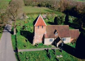
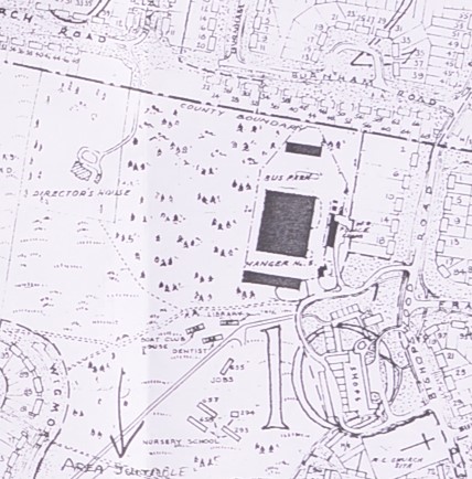
Wartime map showing Bishopswood shops & Hangar 5 that was used for Spitfire assembly in Tadley.
Odd maps/timelines
- Ancient Tree maps
- Water level map https://www.gaugemap.co.uk/
- Timeline of British History, 1066-1487
- https://maps.hants.gov.uk/rightsofwaydefinitivemap/
- Timeline of London Housing (press 3D)
Historical map websites
- https://www.visionofbritain.org.uk/ incredible map resource
- http://www.geog.port.ac.uk/webmap/hantsmap/hantsmap/hantsmap.htm/
- Old Maps Online
- https://astreetnearyou.org/ – contains records for over one million men and women who died whilst serving in the First World War, with over 600,000 locations worldwide, tens of thousands of images, cemeteries, war memorials and much more. Enter Tadley in the search box and it will show everyone from Tadley
- https://bothness.github.io/ons-basemaps/ – Shows side by side maps of the UK with a choice of different map sources (Ordnance Survey 1900 and 1937-1961,OpenMap, OpenStreetMap, ESRI Satellite), optional roads and buildings and a movable slider across the maps.
- https://historicengland.org.uk/research/results/aerial-archaeology-mapping-explorer/ – The Aerial Archaeology Mapping Explorer is a tool that displays archaeology that has been identified, mapped and recorded using aerial photographs and other aerial sources across England.
- https://https://maps.nls.uk/geo/explore/side-by-side/ – Georeferenced Maps allows a set of historical map overlays to be viewed. These are sets of maps that have had their sheet margins cropped and geographical coordinates assigned to the map images to create a seamless georeferenced layer or mosaic, positioned in its correct location in the real world..
- https://www.oldmapsonline.org/map/nls/1059821321
- maps.familysearch.org – An excellent resource for finding neighboring parishes, distance between parishes, jurisdictions of the parish, when records begin, viewing old ordnance survey maps of the parish, view your ancestor’s parish in relations to Google maps and Google Earth.
- labs.nationalarchives.gov.uk/maps/valuation.html – Valuation Office map finder.
- www.visionofbritain.org/uk – Imperial Gazetteer of England and Wales
- www.british-history.ac.uk – Topographical Dictionary of England
- www.genuki.org.uk – Links to maps, gazetteers, etc.
- www.getamap.co.uk – Ordnance Survey Maps
- www.old-maps.co.uk – ($) Access to historical maps in England
- www.ancestry.com – ($) Contains a few English gazetteers
- https://www.archiuk.com (1) – Old Maps and British Archaeological Sites Data for Tadley, Hampshire
- https://www.archiuk.com (2) – Detailed Old Victorian Ordnance Survey 6 inch to 1 mile Old Map (1888-1913) of Postcode RG26 3NN, RG26 3NN, RG263NN in Tadley, Basingstoke and Deane, West Berkshire, Hampshire
Geology and maps
- Interactive LIDAR Maps for the whole of Britain https://enfarchsoc.org/opendata/
- Water level map https://www.gaugemap.co.uk/
Historical maps
- 1575 Christopher Saxton’s map of Hampshire, engraved by Leonard Terwoort.
- 1595 John Norden’s map of Hampshire – Henry Overton edition, published 1670.
- 1605 Peter Keer’s map of Hampshire, English edition, published 1620.
- 1590s-1600s John Norden’s map of Hampshire, William Hole engraving, published Camden’s Britannia, 1607.
- 1611 John Speed’s map of Hampshire, engraved by Hondius.
- 1613 Michael Drayton’s map of Hampshire, to accompany the second song of Poly-Olbion.
- 1643 Mathew Simmons table of distances, and thumbnail map, Hampshire.
- 1645 John Blaeu’s map of Hampshire.
- 1646 Johannes Jansson’s map of Hampshire.
- 1673 Richard Blome’s Mapp of Hantshire and extracts from Britannia.
- 1675 John Ogilby’s road strip maps, Hampshire plates. and text from his itineraries.
- 1695 Robert Morden’s map of Hampshire, published in later editions of Camden’s Britannia.
- 1719-57, John Senex’s road strip maps, Hampshire plates.
- 1720s-50s, Emanuel Bowen’s road strip maps, Hampshire plates.
- 1742 Thomas Badeslade’s map of Hampshire.
- 1750 George Bickham’s perspective view of Hampshire.
- 1751 Thomas Kitchin’s large map of Hampshire, later published in the Large English Atlas by Thomas Kitchin and Emanuel Bowen, 1760.
- 1751 Thomas Kitchin’s small map of Hampshire.
- 1759 Isaac Taylor’s one inch map of Hampshire, Large scale map.
- 1767.Thomas Kitchin’s Post Chaise Companion, Hampshire plates.
- 1785 Daniel Paterson’s British Itinerary.
- 1788 John Harrison’s map of Hampshire.
- 1791 Thomas Milne’s one inch map of Hampshire. Large scale map.
- 1810s Ordnance Survey one inch maps, 1st edition, Old Series, sheets for Hampshire. Large scale map.
- 1823 Aristide Perrot’s miniature map of Hampshire.
- 1826 Greenwood’s Hampshire . Large scale map.
- Kain, R.J.P., Oliver, R.R., Historic Parishes of England and Wales: an Electronic Map of Boundaries before 1850 with a Gazetteer and Metadata [computer file]. Colchester, Essex: History Data Service, UK Data Archive [distributor], 17 May 2001. SN: 4348
Maps, Topography, Miscellaneous
Streetmap Find any place in mainland Britain. Searchable by street, place name, post code, telephone code, Ordnance Survey coordinates, latitute/longitude, telephone code, etc.
Gazetteer of Markets and Fairs in England and Wales to 1516 Compiled by Samantha Letters.
Graesse’s Orbis Latinus An online version of the dictionary of Latin place-names by J. G. Th. Graesse (1909).
Latin Place-Names A brief but useful list of modern equivalents of Latin place-names in early printed books. Searchable both in Latin-to-English and in English-to-Latin.
Historical Atlas of Europe, AD 1-2000 Christos Nüssli’s site provides maps of Europe century-by-century.
Henry A. Harben, A Dictionary of London (1918) Online version of this scarce and very useful topographical dictionary of the City of London.
Sources for Building History A guide to researching historic buildings in the British Isles.
IHR’s “History On-line” reference sites The Institute of Historical Research’s collection of online dictionaries, directories, maps, encyclopedias, train timetables, and other reference works, plus gateways to museums, libraries, and archives.
Latin Vulgate Bible (Biblia Sacra Vulgata) Searchable text of the Vulgate Bible (Douay-Rheims version of 1589-1609, revised 1749-52), from an edition published in Baltimore in 1899.
IBIS (Institute for British and Irish Studies) Links to numerous electronic resources in British and Irish Studies. Based at the University of Southern California.
Monumental Brass Society, Picture Library Online library of medieval brasses, including engravings of brasses that no longer survive. Searchable by name and by topic.
The Medieval Bestiary Excellent scholarly site on medieval bestiaries and on animals in the Middle Ages, including a topical encyclopedia, a digital text library, a handlist of important manuscripts, and a bibliography.
ORBIS The Stanford Geospatial Network Model of the Roman World ORBIS: The Stanford Geospatial Network Model of the Roman World reconstructs the time cost and financial expense associated with a wide range of different types of travel in antiquity. The model is based on a simplified version of the giant network of cities, roads, rivers and sea lanes that framed movement across the Roman Empire. It broadly reflects conditions around 200 CE but also covers a few sites and roads created in late antiquity.
Other unlinked maps
-
-
- 1535-43. John Leland’s observations about Hampshire made on his itinerary
- 1607 ? William Camden’s descriptive text for Hampshire from Britannia, translation by Holland 1610.
- 1724-26 Extracts about Hampshire from Daniel Defoe’s guidebook a Tour through the Whole of Great Britain .
- 1738 Thomas Cox’s descriptive text about Hampshire from Magna Britannia, Antiqua et Nova, about .
- 1815 Entries for Hampshire from Richard Brookes’s General Gazetteer, 16th edition .
- 1815 Hampshire parts of route descriptions from John Cary’s New Itinerary, 6th edition .
- 1830 Extracts about Hampshire from William Cobbett’s Rural Rides, .
-
Leaflet Map
Remote Sensing imagery
- Earthdata
- www.usgs.gov United States Geological Service (access to many satellite images)
- US Geological survey maps
- www.visibleearth.nasa.gov Visible Earth
- http://earth.google.com/ Google Earth
- http://worldwind.arc.nasa.gov/ WorldWind
- http://glovis.usgs.gov/
- Landsat
- SPOT imagery
- https://www2.jpl.nasa.gov/srtm/dataprod.htm Jet Propulsion Laboratories, NASA and SRTM Data
- USGS real time data
- USGS National map data download
- http://glcf.umiacs.umd.edu/data/srtm/index.shtml
- http://srtm.csi.cgiar.org/
- www.digitalglobe.com Quickbird imagery
- http://www.satimagingcorp.com/ IKONOS Imagery
- http://www.satimagingcorp.com/
- http://www.jpl.nasa.gov/radar/sircxsar/
LIDAR Imagery
Satellite Archaeology
- http://www.space.gc.ca/asc/eng/satellites/radarsat1/
- http://gs.mdacorporation.com/products/sensor/radarsat/rs1_price_ca.asp8th 2008
- http://cobweb.ecn.purdue.edu/~biehl/MultiSpec/ Free multispectral program
- http://grass.osgeo.org/ Free multispectral program:
- http://www.uni-koeln.de/~al001/airphoto.html Satellite viewer
- http://www.lizardtech.com/ Mr SID GeoExpress View
- http://www.ermapper.com/productview.aspx?t=160
- http://www.pcigeomatics.com/services/support_center/downloads/downloads_main.php Geomatica Freview
- http://gi.leicageosystems.com/LGISub2x44x0.aspx ERDAS Viewer (requires registration):
- http://rsinc.com/download/download.asp?searchstring=FreeLook&ProductVersion=All+ ENVI Freelook
- www.jeeep.com converting coordinates
Satellite Archaeology
- www.savingantiquities.org
- http://lootingmatters.blogspot.com/
- http://www.popsci.com/scitech/article/2008-05/space-archaeologists?page=1
- http://www.newswise.com/articles/view/530280/
- http://news.nationalgeographic.com/news/2006/11/061107-archaeology.html
Other sources
- Hampshire Tithe Maps –The History of Maps
- Tithe Maps The first tithes can be traced back to the 9th century and King Ethelwulf of Wessex. A tithe was an ‘in kind’ payment made to the local church, typically 10% of an individual’s produce. As this was typically stock or crop, great tithe barns were built by local monasteries or churches in which to collect tithes within the parish; many of these barns still survive around the county today.
In 1836 the Tithe Commutation Act made it possible to pay tithes in cash, equivalent to 10% of an individual’s produce. This legislation required that detailed maps be drawn up on order to identify land ownership and use within the parish. Each map was supported by a document called the tithe apportionment, which detailed the owners, the nature of the land they possessed and the rent charges they were liable to pay. Three copies of each map were made. The first was held by the tithe commissioners and later passed to the Inland Revenue. These copies are now in the care of the National Archives. The second would be kept in the diocesan registry and the third in the local parish church. More often than not it is the diocesan copy that passed to HRO. Almost the entire county is represented in the HRO – only five parishes are without tithe maps. Although they were drawn up to depict private land ownership rather than highways, tithe maps give us a very good idea of road and track networks in the parish in the early 19th century. These are usually depicted as physical features and don’t always indicate whether or not routes were public or private, or byways or bridleways. However, sometimes they may inadvertently show routes that were considered public on account of the fact that they aren’t privately owned.
- Tithe Maps The first tithes can be traced back to the 9th century and King Ethelwulf of Wessex. A tithe was an ‘in kind’ payment made to the local church, typically 10% of an individual’s produce. As this was typically stock or crop, great tithe barns were built by local monasteries or churches in which to collect tithes within the parish; many of these barns still survive around the county today.
-
- Enclosure Maps
The process of enclosing England’s field systems was not an overnight one; many parts of the countryside were enclosed hundreds of years before others. This was often done by private arrangement or legal agreement and it wasn’t until the 1801 Inclosure Act and the 1845 General Act that the process became formalised. Under these acts, commissioners allotted land to
individual landowners. Maps and awards were created to detail the changes, and these documents often provide excellent information about land use. Unfortunately, as many parishes had already been enclosed by private agreement before the act, often no formal maps exist. However, where they exist they provide an important record and carry the most evidential weight when identifying lost routes, as they were drawn up as a legal record of public highways as well as land ownership. The traditional spelling was Inclosure, but as you are no doubt aware, Enclosure has become a more popular variation. The Record Office primarily uses Enclosure, so that spelling will be used for the rest of this guide. That said, if a computer search of their catalogue doesn’t turn much up, consider trying both spellings.
- Enclosure Maps
-
- Highway Handover Maps
In 1929 the responsibility for county highways was passed from district and borough councils to the county council. For the purposes of the transfer, public highway ‘handover’ maps were drawn up to identify all of the public highways within the county. These were based on existing OS maps and supposedly edited to mark public highways – from
A-roads to footpaths. However, these maps suffer from several flaws – most particularly that often, if a right of way was not surfaced, it was often not recorded. A right of way marked on these maps is very good evidence, but many public highways that existed both before and after the handover are not marked either. Also, this document did not have the benefit of any sort of public consultation or scrutiny so may be said to carry less evidential weight than others.
- Highway Handover Maps
-
- Ordnance Survey
It’s often forgotten that the first OS maps were drawn up for military purposes (a fact reflected in the name – ordnance being another word for ammunition). After successfully mapping the Scottish Highlands in order to organise the subjection of the clans there, the Board of Ordnance (now the MoD) began a full survey of the country. The very first OS map, covering Kent at a scale of 1 inch to 1 mile, was produced in 1801. However it would be more than half a century before the rest of the British Isles were complete. The new Ordnance Survey was based in the Tower of London until a fire forced them to relocate. In 1841 they moved into the old cavalry barracks on London Road in Southampton where they remained until German bombing during the Second World War forced the offices to disperse. In 1969 they returned to Southampton in the purpose built headquarters in Shirley and in 2010 they began moving to new offices on the city’s outskirts near the M271. A more thorough history of their work is available on their website.
- Ordnance Survey
-
-
Current Maps held by TADS
The following maps are held online (members only).
The following maps are held as paper documents in our archive.
- 1595 Nordens map.PNG
- 1675 Saxtons map.PNG
- 1810 Tadley map 1810 sheet v1.4.pdf
- 1816 Tadley Centre portion – Old Series 1816-30.pdf
- 1817 148e27sheet12.jpg
- 1817 148e27sheet12.txt
- 1817 Tadley – Old Series 1816-30.pdf
- 1826 Greenwood.PNG
- 1832 Hampshire parishes before this date.jpg
- 1838 Parish of Pamber.jpg
- 1840 Parish tithe map of Tadley.jpg
- 1847 Big green book
- 1847 green book.jpg
- 1870 Tadley Pamber Monk Sherbourne, Wooton St Lawrence HX6.jpg
- 1871 Survey ‘Map of 1913’ H X.jpg
- 1871 Survey ‘Map of 1913’ H X.jpg.points
- 1871 Survey ‘Map of 1913’ H X_modified.tif
- 1871 Tadley 1871 reg dist.pdf
- 1872 Aldermaston, Silchester, Pamber,Tadley, Stratfield, Mortimer B XLIV 15.jpg
- 1872 Pamber, Silchester,Bramley & Tadley Parishes H X3.jpg
- 1873 -Tadley, Baughust and Pamber Parishes H-X2.jpg
- 1873 Baughurst, Wolverton, Ewhurst, Kingsclere,Hannington, Monk Sherbourne+Dets H X5.jpg
- 1873 Brimpton, Aldermaston, Kingsclere,Baughurst and Tadley Parishes H IV-13 B XLIV 13.jpg
- 1873 bTadley, Baughurst, Pamber, Parishes.jpg
- 1873 Tadley, Baughurst and Pamber H X2.jpg
- 1873 Tadley, Baughurst, Pamber, Parishes .jpg.aux.xml
- 1873 Tadley, Baughurst, Pamber, Parishes.jpg
- 1873b Tadley, Baughurst, Pamber, Parishes 1873b.jpg.aux.xml
- 1880 Tadley Inclosure map B2 large.jpg
- 1894 Tadley North Six inch 1894-99.pdf
- 1894 Tadley South Six inch 1894-99.pdf
- 1894-1899 Six inch County series map.JPG
- 1896a.PNG
- 1896b.PNG
- 1896c.PNG
- 1896d.PNG
- 1896e.PNG
- 1896f.PNG
- 1897 Pamber Heath and Burney Bit.jpg
- 1897 Tadley Revised New series 1897 – 1900.pdf
- 1900 OS 25__- Bekshire XLIV.14 1900.jpg
- 1901 Tadley, Pamber Heath Wolverton Common.jpg
- 1911 Kingsclere Aldermaston and Baughurst Parishes ‘Edition of 1911’.jpg
- 1911 ‘Edition of 1911’ B XLIV.10.jpg
- 1911 ‘Edition of 1911’ B XLIV10.jpg
- 1911 OS 25__- Bekshire XLIV.14 1911.jpg
- 1911 Tadley Civil Parish Boundary.jpg
- 1911 Tadley Parish 1911 1 in 10000.pdf
- 1913 crop.jpg
- 1913 hampshire map.PNG
- 1913 OS.jpg
- 1913 OSb.jpg
- 1913 Wasing ‘Edition of 1913.jpg
- 1913.jpg
- 1913b.jpg
- 1917 OS 25__- Bekshire XLIV.14 1937.jpg
- 1919 Tadley Popular Edition 1919.pdf
- 1923 Plan of Property at West Heath Ramsdell.jpg
- 1936 ‘Revision of 1936’ B XLIV.14 H IV.14.jpg
- 1936 Parish of Baughust. Aldermaston & Tadley ‘Revision of 1936’.jpg
- 1940 approx Concentric area around Aldermaston Aerodrome.jpg
- 1940 B approx Concentric area around Aldermaston Aerodrome.jpg
- 1940 Tadley New Popular Series 1940-47.pdf
- 1943 Airfield Record Site plan.jpg
- 1943 AWRE Record Site plan.jpg
- 1945 Aldermaston Record Site Plan.jpg
- 1956 AWRE Housing.jpg
- 1956 Tadley 1956 OS 1 to 10,560 scale.pdf
- 1961 Map of Hampshire.jpg
- 1961 Map of Tadley Common.jpg
- 1969 Tadley.jpg
- 1981 Tadley Conservation Area.jpg
- 2008 Tadley 2008 OS cropped.pdf
- 2019 0929_223408.jpg
- 2019 1017_172850.jpg
- 2019 1028_213011.jpg
- 2019 Lidar.png
- 2019 Modern Tadley.pdf
- 20191017_172550.jpg
- 20191017_172602.jpg
- 20191017_172629.jpg
- 20191017_172830.jpg
- 20191028_214434 (1).jpg
- 20191028_214434.jpg
- 20191128maps-Tadley-8-300×242.jpg
- 2020 Swallowfield rivers.PNG
- 2020 Tadley geology map v1.1.pdf
- GENUKI_ St Lawrence, Wootton St Lawrence, Hampshire.html
- [GENUKI_ St Lawrence, Wootton St Lawrence, Hampshire_files]
- Libray Map collection 1.jpg
- Libray Map collection 2.jpg
- Libray Map collection 3.jpg
- Libray Map collection 4.jpg
- Libray Map collection 5.jpg
- Libray Map collection 7.jpg
- Libray Map collection 8.jpg
- [maps tadley 1600×1200]
- Maps.mht
- Old Map A.jpg
- Old map B.jpg
- Old map C.jpg
- Portsmouth hampshire old antique Maps _ Portsmouth old antiq… _ Flickr.html
- [Portsmouth hampshire old antique Maps _ Portsmouth old antiq… _ Flickr_files]
- TADS MAPS.index.htm
- Turnpikes.PNG
- 2012 Pipelines and pylons map FOI request
-