Contents
Introduction
Ivan D Margary’s’ Roman Roads in Britain’ was published in 1955.
Maps of Portway
Roman Roads in Britain by Thomas Codrington
Are Portway locations on the OS maps correct?
Reading University at Silchester
Alex Flahive
The Old Road
LIDAR
References
Introduction
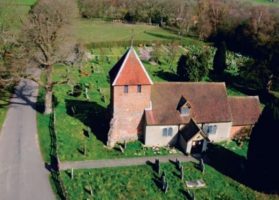
The Portway is a 58 km road between Roman Silchester (Calleva Atrebatum) and Old Sarum. [1] The route passes through Pamber Forest. It does not follow the line of any significant path in the forest and therefore is not easily located. it crosses the long north-south route through the middle of the forest and the A340 road just north of Honey Mill Bridge (636 623) follows parallel to the current road to Skates farm, passing to the south of St Peter’s Church. It then passes through [2] Tadley Place and the two detached villages of Tadley before continuing on to cross the A34 at Lichfield [3] , subsequently passing via Hannington on its way to Old Sarum.
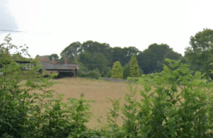
The agger near Skate’s farm is visible on the Sept 2018 Google Earth view.
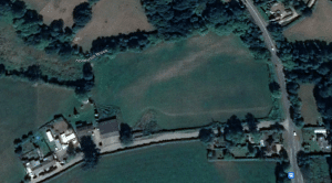
The Portway seems to pass between two notable features (trees? at the farm).
Return to top
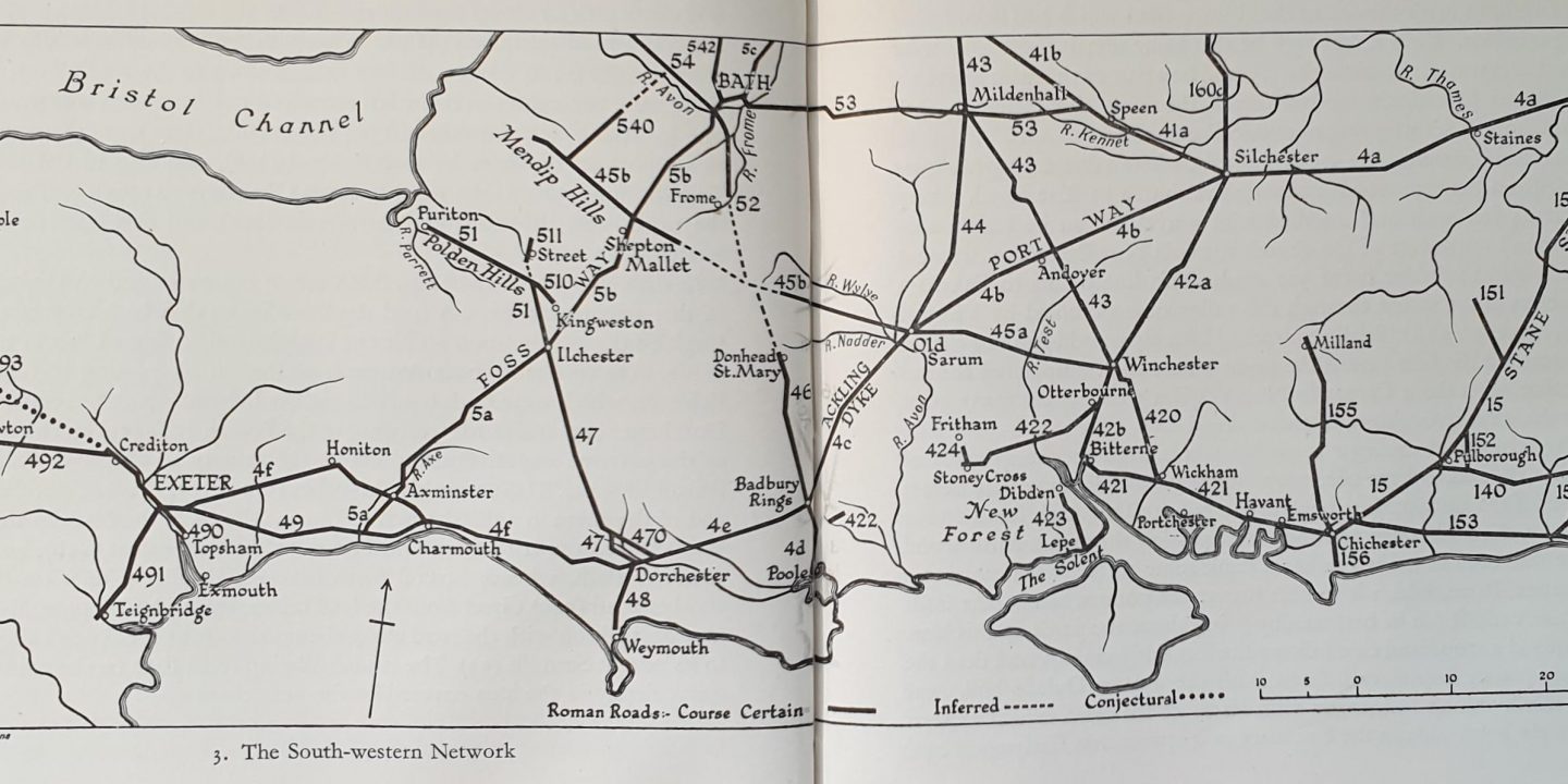
Ivan D Margarys’ Roman Roads in Britain’ was published in 1955.
Page 89 4b. PORTWAY, SILCHESTER-OLD SARUM (36 1/4 miles)!
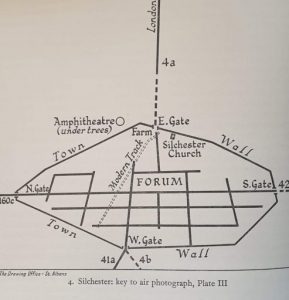
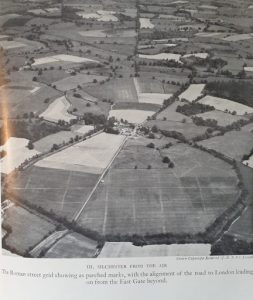
At the West gate of Silchester (Calleva Atrebartum), the western route forks north-westward to Speen and Gloucester with a branch to Bath , and south-westward to Old Sarum and the west. At first, this route is obscured by the extensive excavation of the Flex Ditch, and then it traverses Pamber Forest where little can be seen through at the western exit from this wood, at Tadley, a piece of the agger can be traced just south of the present track and inside the wood. After crossing the main road at Tadley is visible as a large agger running from the stream at Honey Mill Bridge up to Skate’s Farm, whose buildings stand across the line.
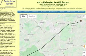
It is said that the line can be seen in the crops west of the farm parallel with the hedgerow a few yards south of it. Some faint traces mark the line north of Stony Heath, but little can be seen till the high downs near Fremantle Park Farm are reached, 7 miles from Silchester. This point was evidently the main sighting mark, for the alignment changes slightly more to the west near here. A magnificent vista of the route now opens up to the southwest, past Walkeridge Farm, first along a lane generally on or slightly north of the agger and then by a line of hedgerows for 43 miles to Clap Gate, where the Newbury Winchester railway is crossed. In Bradley Wood, just beyond, the agger is very well preserved, some 27 feet wide. More... Two miles farther on, the road passes through St Mary Bourne, and remains of the agger are visible as it ascends the western side of the valley. In 1879 the old road was removed here and was 24 feet wide, the metalling being 4-8 inches below the surface. Near the crest, the modern road comes onto the line and follows it very closely for 2 miles past Finkley, whose farmhouse stands right upon the agger. Near East Anton, the route leaves it again, and a hedgerow marks the line to the point it miles northeast of Andover where the Winchester Cirencester road (43) crosses it at right angles. The exact alignment, slightly modified at the awkwardly placed crossing of the River Anton, continued past Andover. Still, there is no trace of it, save perhaps a slight swelling and stoniness in the field between the huge electricity switch station (just north of its line) and Old Mill Farm, until at the Weyhill Road, the modern road to Monxton resumes the line. Between the railway bridge and Monxton, it is, however, a few yards north of the old highway whose flattened agger is just visible in the fields Through Amport Park, the ridge is again visible beside the road where this bends slightly. Still, near Quarley and Grateley, it seems probable that the distinct ridge along the south side of the broad green lane marks it, rather than the Ordnance Survey’s idealised straight line in the fields where there is no sign of it. The road passes | mile to the south of Quarley Hill Camp, a prominent landmark, and a slight turn to the southwest was made there, pointing directly to Old Sarum 9½ miles on. The agger is mostly well preserved or used as a trackway. West of the Amesbury branch railway, it is evident, 27 feet wide and raised feet. It has been ploughed out Near Boscombe, and at Idmiston, buildings have obscured it. Still, after crossing the river at Winterbourne Gunner, the modern road follows it for 2¼ miles until close to Old Sarum (Sorbiodunum), upon whose entrance it was aligned. REFERENCES This road, called the Portway, was supposed by Sir R. Colt Hoare to branch off from the Winchester Road outside the south gate of Silchester, in the wood below the wall, where he says it was visible. A comparison of his map with McLauchlan’s (1850) shows that the Roman roads of the former are ancient entrenchments in the latter. The new Ordnance map, on what authority does not appear, shows the road by a dotted line from the West Gate, through Pamber Forest, and by Tadley Place Farm to Foscot. Sir R. Colt Hoare failed to trace it, and MacLauchlan, in 1851 12, found not the least vestige of the road eastward of Foscot. There the tertiary beds are quitted, and on the chalk escarpment, six miles from Silchester, the ridge of the road is shown on the old Ordnance map for one and a half miles pointing towards the south side of Silchester, and in the opposite direction to high ground (700′) at Freemantle Park Farm, but it is now hardly traceable. At Freemantle Park Farm (700′), there is a very slight change in direction, and the road appears to have been directed to the high ground (450′) on the south side of Quarley Hill, nearly 19 miles off. The ridge was formerly traceable by Walkridge Farm and over Ridge Health for four and a half miles, but it has been effaced by planting a belt of trees along with it. The line is fortunately preserved by parish boundaries for three and a half miles to Bradley Wood, beyond which traces of the road are lost for two miles and a half. About a half-mile on the west of St. Mary Bourne, the paving of the road was removed in 1879 for a length of a quarter of a mile on account of its interference with farming operations. It was found from four to eight inches below the surface and was about eight yards wide. The outline of the road is traceable in the wood to the eastward, and the course of the Portway onwards is taken up by the present road to Andover by Finkley. At Finkley, eighteen miles from Calleva, Sir R. Colt Hoare placed Vindomis, a station named in Iter XV, but the distance from Calleva and Venta Belgarum would set the station to the east of St. Mary Bourne.[4] More... The Roman road from Winchester to Cunetio and Cirencester crosses the Portway about one mile to the west of Finkley. Still, there are few traces of the latter for two and a half miles across arable land until the Andover and Weyhill road is reached. In a straight line with the course of the Portway, which can be seen by Finkley and towards St. Mary Bourne, is a road to the south-west followed by a parish boundary. The same line is continued by the road onwards through Monkston and Amport to the south side of Quarley Hill, from which, looking eastward, the p302 course of the road can be traced in a straight line to Freemantle Park, more than 18 miles distant. There is then a turn, and the road line lies straight between the south side of Quarley Hill and the south side of the central mound of Old Sarum, ten miles off. From the top of Quarley Hill, Old Sarum is visible, as it would doubtless be from the line of the Roman road on the south slope of it if a plantation of trees did not intervene. The present road occupies the course for about half a mile, and then there is a track over the downs, generally a slightly raised grass-covered ridge, but in places worn down to the flint surface of the old road. In about a mile, the railway approaches it on the south and runs close alongside it for three and a half miles near Idmiston. The appearance continues on downland, but the road is no longer traceable where the land has been ploughed up. On the down on the east of Idmiston, the ridge of the road remained inside the railway fence until the railway was lately widened. At the descent into the Idmiston valley, the track of the Roman road leaves the railway and diverges somewhat from the straight course in crossing the valley. It is shown on the old Ordnance map resuming the same straight line and passing round a barrow, but all traces of road and barrow are now effaced by ploughing. Through Porton and Gumbleton, the course of the road is uncertain, but on the other side of the Bourne valley, it is shown by a line of highways and tracks pointing p303 straight to the south side of the central mound of Old Sarum and continuing to within half-a‑mile of it.[4] A straight line from Silchester to Old Sarum passes a mile to the south of the Roman road at Quarley Hill, where the road lies farthest away from a straight line in the 36 miles between those places.[4] It is to be noticed that this road, the Roman road from Winchester, and that on to the west, all three point to the inner of the two immense concentric ramparts of Old Sarum. The outer ring, which is supposed to have been strengthened by Alfred, has a mean diameter of about 520 yards.[4] This road left Calleva by the south gate, and the road marks its course by Three Ashes and Hall-in‑the‑Hole to Latchmere Green. Sir R. Colt Hoare says7 that the ridge was “seen very fine” behind a barn on the side of the road from Three Ashes to Scotchman’s Green, but he appears to refer to an earthwork a quarter of a mile p294 away from the line of the Roman road, and the pitching of the latter has since been opened on Latchmere Green.8 For three miles from Latchmere Green, the course is obscure, but on mounting the chalk at Sherbourne St. John the line is taken up by the present road, and by a track over Rook’s Down, on the highest point of which (440′) a short bit of the ridge remains supporting two fir-trees. From this point, Silchester is visible, and a lane, followed by a parish boundary, continues the line for a mile and a half to Worting Cross. The parish boundary continues on in the same straight line for four miles from Rook’s Down and no doubt marks the course of the Roman road, of which there is now no trace on the ground. Near Southwood Farm, the parish boundary bends and is soon joined by the Basingstoke and Winchester road, along which it runs to the Wheatsheaf Inn. It would seem that the Roman road was laid out in a straight line between Rook’s Down (440′) and high ground (552′) between Southwood Farm and Kempshott House and that the high ground was avoided on approaching it by the turn near Southwood Farm. The course of the Roman road appears to continue in the same straight line from the Wheatsheaf to about a mile south of Popham, the present road lying a little to the west of it; there is then a slight turn, and the modern road, followed by a parish boundary for three miles, occupies the line of the old road along the west side of Stratton Park, and on in a straight line to King’s Worthy. The route then turned away from the p295 river and passed through Headbourne Worthy in a course not very plain, and then followed the line of the present road in a straight line as far as Abbot’s Barton, through the grounds of which the same straight line is continued, and where some remains of the ridge can still be traced. The course onwards to the site of the north gate of Venta Belgarum (Winchester) is now covered with buildings. The Roman city, on the west of the River Itchen, was a rectangle with rounded corners, measuring about 860 yards from the east gate near the river-bank to the west gate at the other end of High Street and about 780 yards from the north entrance to the south gate; the principal cross street of the Roman city being marked by Southgate Street and Jewry Street at right angles with High Street. A Roman road left the south gate of the city, the course of which the present route follows through St. Cross to Compton between the latter place and Otterbourne. The old Ordnance map shows the ridge of the road for half a mile close alongside the present road on the east of it. It can be traced in Otterbourne Hill Wood but not beyond unless Stoneham Street indicates the line. It led to the Roman station on the east bank of the Itchen at Bitterne, where near the east end of Northam Bridge, a vallum 460 yards long cuts off a promontory, generally supposed to be Clausentum. Iter VII of Antonine from Regnum to Londinium passes by Clausentum, Venta Belgarum, Calleva, and Pontes. Between London and Clausentum, the p296 Itinerary distances agree reasonably well with measurements on the map, bringing Pontes a mile or more to the west of Staines, a more likely situation than on the low ground by the Thames. Still, the distance between Clausentum at Bitterne and Regnum (Chichester) is 28 miles, compared with 20 M.P. in the Itinerary. There appears to be now no trace of a Roman road from Bitterne in the direction of Chichester. A Roman road said to have come from Bitterne, but more probably from the Winchester road on the west of the River Itchen, has been described as passing along Burgess Street and the north of Southampton Common, where the road is a parish boundary for a mile, over Shirley Heath to Nursling, where it crossed the river Test at a ford near the mill. On to Tachbury Mount, near which a fragment remained in 1834. The Roman road, of which traces remain on Beaulieu Heath, presumably branched from this road to Lepe, whence it is supposed the Solent was crossed to the Isle of Wight. Rew Street, running southward from Gurnard Bay, has been thought to show the point of landing on the island, but there is no evidence for that or any other Roman road in the Isle of Wight. The road from Roman London towards Silchester has been noticed as far as the original Watling Street at the south end of Edgware Road . From the Edgware Road, the course continues to Notting Hill along the line of the Bayswater Road, which a parish boundary follows nearly to the Westbourne stream. There is then a slight change of direction, and thence to Staines, 14½ miles, the course of the road is so direct that it is nowhere more than a quarter of a mile out of a straight line. It would seem that from Notting Hill, on the edge of a terrace 95 feet above the sea and overlooking the Thames valley, some landmark or beacon, on the ground (175′) near Upper Bakeham to the south-west of Egham, was the point to which the course of the road was directed. From Upper Bakeham, the towers of South Kensington and Westminster can be seen, and the. The mound at Upper Bakeham must have been equally visible from Notting Hill before houses obscured the outlook. From Notting Hill, the Roman road followed this line, which is the general course of the present high road until the latter turns southwards towards Chiswick. Stukeley rode on by a narrow straightway to Turnham Green, where the trace of the road was manifest to a discerning eye.1 Parish boundaries, which have followed the present route all along, continue straight on in the same line by Stamford Brook Road to Stamford Brook, through Bedford Park, across Acton (Turnham) Green, and south of Acton Green railway-station, to near Gunnersbury station, and then along the high road again, and indicate the course of the Roman road to near Kew Bridge railway station. The straight line appears to have been departed from to keep clear of the Thames, and through Brentford, and on nearly to p289 Hounslow, the course of the road is uncertain. It is probably followed by the present road, curving northwards near Spring Grove to avoid a stream. From the east end of Hounslow, lengths of straight road, almost in the same line, followed almost continuously by parish boundaries, indicate that the present route follows the course of the Roman road to Baber’s Bridge. The Roman road itself was uncovered by General Roy at the end of the eighteenth century on Hounslow Heath, at the side of the modern road. For two miles on to East Bedfont, a parish boundary runs straight a little on the south of the contemporary high-road, and then the latter, with a slight turn, goes straight to Staines with parish boundaries along with it for the last mile and a quarter. The straight line crosses the Thames to Hythe a little to the south of the present bridge, and near the site of the old bridge, to the west of which Stukeley saw the old road very evidently go through the fields, the ridge being then visible, but no sign of it now appears. He traced it along a lane and a footpath towards Thorpe Lea. In 1835 the officers studying at Sandhurst surveyed the Roman road onwards to Silchester, and a memoir was furnished to the United Service Journal.3 At Bakeham House, now called Upper Bakeham House, the substratum of the road, and also the foundations of a building, and other Roman remains, had then lately been discovered, proving apparently that the p290 straight course of the road had continued from Notting Hill to that point. In the valley, nearly half a mile to the south of this line, a stone pillar erected near Great Fosters in 1850 records that it marks the site of a Roman road to Silchester, a portion of which remains in the adjoining meadow. If so, the road did not continue straight on but bent to the south after crossing the Thames; the pillar may, however, mark a branch road’s site. Beyond Bakeham, the memoir referred to states that the direction was through the yard of the inn at Virginia Water, where according to the tradition of the foundation of gravel, supposed to be the Roman road, had formerly been discovered, and also that the line cuts Virginia Water, and that the ridge could be distinguished for 300 yards, where one of the drives in Windsor Forest ran along with it. The inn’s yard seems to be out of a line across any part of Virginia Water, and no trace of the ridge is now distinguishable on to Belvedere, and the course of the road is uncertain. Likely, the hill on which the Belvedere Tower stands (260′) was the point made for from Bakeham Hill, though the road perhaps avoided it. Beyond, the course of the road lies in a straight line between it and Duke’s Hill, Bagshot (300′), the direction changing slightly, but the road from Notting Hill to Duke’s Hill is so nearly straight for 23½ miles that no part is as much as •three-quarters of a mile away from a straight line between those places. At Sunningdale, the road is found in digging in the allotments near the church, and it was until lately visible p291 on by King’s Beeches, and by Chater’s Pond, and to the back of Windlesham Hall, where the county boundary marks the line of it for •a mile and a half. Enclosing, planting, and laying out the grounds of new houses have now almost effaced all trace of it. About a mile from Duke’s Hill, it is described in 1835 as being raised to a considerable height where it crossed a marsh. At Duke’s Hill (300′), there is a change of 27° in direction, and the road goes nearly due west for 16 miles to Silchester. Under the local name of the Devil’s Highway, it passes over Easthampstead Plain in a straight line to a point (311′) called Crowthorne on the old Ordnance map, and then in nearly the same line to Ridge Farm, Finchampstead (331′), and with a slight turn southwards on by St. James’ and West Court. Easthampstead Plain passes a mile south of a large entrenchment called Caesar’s Camp, between which and the road, at Wickham Bushes, Roman coins and pottery are found. The Devil’s Highway is said by Bishop Bennet4 to have been raised with a trench on each side and to have been 90 feet wide, which probably included the trenches. When the ridings were cut, it was leveled at the beginning of the last century. In 1835 portions were still existing to the north of Finchampstead Church. It crossed the Blackwater at Thatcher’s Ford, and the river Loddon at Stanford, near the north of Stratfieldsaye Park, and beyond that, Park Lane, also called the Devil’s Highway, with the county boundary along with it for two miles, runs in a straight line to the east gate of Silchester (Calleva). From Duke’s Hill, Bagshot, to Silchester, 16 miles, no part of the road is a quarter of a mile out of a straight line joining those places. From near Duke’s Hill, a Roman road has been supposed to have gone southward to Frimley, Farnborough, and Farnham, and the change in the direction of the Silchester road has been thought to confirm the supposition, but without much reason. Stukeley tells us5 that he traced a Roman route from Winchester to Farnham and Farnborough, which he supposed went on to Staines. He says that between Farnham and Alton, the bank was visible, and in several places between Alton and Alresford. There appears to be no evidence of this road. On ground 300 to 320 above the sea, Silchester is in shape an irregular polygon 820 yards from the east to the west gates and 803 yards from the north to the south gates. Outside the town, walls are earthworks of uncertain age. Five Roman roads converge to Calleva, approaching it in different directions, and it cannot be doubted that it owed much of its importance to its being the place where the road from London branched in many directions. The excavations carried on in recent years show that the street in continuation of the road from Staines runs straight from the east gate to the Forum, and a parallel street about 93 yards to the north of it leads to the west gate. A road at right angles to these led from the north to the south gate. The east and west gates consisted of two covered passages, 13 feet wide, separated by a middle pier, while the north and south gates had only one course of 13 feet. There was no doubt a road from Calleva northwards, but there is nothing to show its course with any certainty, nor could Bishop Bennet trace it at the beginning of the last century. Faint traces appear to have been observed in 1837 in a line between the north gate of Silchester and Ufton Church, and 25 or 30 years before that, the road is said to have been traced by excavations in that line for 800 yards.6 The modern road by Englefield to the ancient ford across the Thames between Pangbourne and Whitchurch is a continuation of the same line. The indications of a Roman road in this direction on the west of the Thames through Streatley to Dorchester have already been noticed. A road from Silchester to Speen (Spinae) appears in Iter XIII and Iter XIV of Antonine. It issued from the west gate, and its course is indicated by a highway with a parish and county boundary for three and a half miles, beyond which it is little or no trace to Speen, where the roads branched. Beyond Speen, following Iter XIV in the reverse direction, there is little or no trace of the road as far as Cunetio. It probably followed the line of the Bath road from Newbury towards Hungerford and continued by Rudge1 to the north of Hill Barn, on the south side of the Kennet valley, about three-quarters of a mile to the east of Mildenhall, where the ridge remains on the down. Sir R. Colt Hoare, in his map of Cunetio, shows the Roman road onwards to the lane at Cockatrip Cottage, along the south of a field in which many coins and fragments of pottery, etc. have been found. He also shows “an earthwork of a square form by which the parish church was surrounded, which he supposed to be a Roman camp, and called Lower Cunetio. Traces are visible, but there is good reason to think they are not Roman. There is undoubted evidence of a Roman settlement in the more sheltered valley, but the camp on the high ground at Folly Farm must mark the Roman station Cunetio. There are no indications of the Roman road onwards through Marlborough. Stukeley supposed that there were remains of a camp near the river in what is now the garden of the Master of the College, but R. Gale found that he was mistaken. The first trace of the road is three miles further on, near West Overton, where a short length of the ridge is shown on the old Ordnance map on the north side of the Bath road, and it is still traceable. A little further on near East Kennet, Sir R. Colt Hoare observed the causeway five feet high and 18 or 20 feet wide, and the ditches were distinct in 1884. The road passed around Silbury Hill on the south side, and although it has been ploughed up, it is now sometimes traceable by the eye. In 1867, to test Mr. James Fergusson’s contention that Silbury was upon the Roman road, some sections were cut across the road, and the trenches on each side of the road were found at a distance of 18 feet apart and were traced around the hill to the straight portion of the road on the west of it. The road there ranges with the south side of the mound, and it can be traced in dry summers. From Silbury, the course is straight for two miles and a half to a point (665′) on a spur of Calston Hill. A slight curve brings the road in •a mile and a half to the 700 feet contour line on the north side of Morgan’s Hill, along which it is carried on a terrace about five yards wide, cut into, and embanked upon, the slope of the hill. The banking up is considerable, where it passes around the head of a coombe at Horse Coombe Bottom Wood. On the west of Morgan’s Hill, the Roman road is joined by Wansdyke, an entrenchment that crosses the Wiltshire Downs for many miles and is traceable from the borders of Hampshire to this point. It follows a devious course and varies a good deal in size; over Morgan’s Hill, it is unusually crooked and consists of a ditch with a rampart on the south side and a slight counterscarp on the north. The crest of the rampart is nine or ten feet above the down and 18 to 20 feet above the bottom of the ditch as they now exist, and rampart and ditch together measure eighty to ninety feet across. Coming over the hills, it joins the Roman road at an acute angle, and Stukeley thought that there was “incontestable proof that it was in being before Roman times” and that the Roman road followed the course of Wansdyke. Local antiquaries have generally insisted on the pre-historic, or at least pre-Roman age of the great intrenchment, and that the Roman road took the line of it. If so, as Sir R. Colt Hoare pointed out, we must suppose that Wansdyke, which winds about through all the rest of its course, takes an absolutely straight line for three miles to Wansdyke, and then again for 10 miles on to Ashley Wood, making together 13 miles of straight course along which a Roman road follows it. The excavations made by General Pitt Rivers in Wansdyke close by prove from coins that the work is Roman or post-Roman in date, and the earthworks themselves show how the pre-existing Roman road was made use of by the makers of Wansdyke. The road, which is on a terrace five or six yards wide along the steep north slope of the down, is joined on the south by Wansdyke, here a deep ditch with a high rampart on the south of it, together some 27 or 30 yards wide, at the head of a coombe about a quarter of a mile east of the Calne road; and there the whole character of the intrenchment changes. There is no longer a rampart on the south of the ditch. Still, the edge of the embanked terrace has been raised by material excavated from a ditch along the road and thrown up as a counterscarp some four feet high on the north of the ditch, the steep slope of the down rendering any other defense unnecessary and the whole is not more than 17 yards wide. It is probable that the rampart crossed the road and joined the counterscarp, but a cart-track now obliterates that. As the hill-side slope gets less steep going westward, a rampart appears on the south side and increases in height, and near Smallgrain plantation, to the east of the Calne and Devizes road, there is a large bank on either side of a hollow way. We have identified the Portway location as a critical issue for the lost village project. For some time, there have been concerns that the OS route of the Portway may be not accurate. Several references question the location of the Portway, and there seemed to be some uncertainty about exactly where the Portway entered Calleva Attrebatum. A Roman road on OS maps that passes through Pamber Heath has added confusion in the past. ( Warning… Saxonhistory.co.uk website suggests the Portway is significantly north of its position on OS maps). Quote from Saxonhistory.co.uk “This website shows the Portway. The map shows Roman roads in black derived from Ivan D Margarys’ Roman Roads in Britain’ published in 1955. (see above) These maps are plotted as accurately as is possible from the books. There are problems with mapping 50 years later as significant road and town changes have hidden some of the original places mentioned in the texts. The red roads are derived from Ivan D Margary’s’ Roman ways in the Weald’ published in 1948. Central Roman locations are shown as icons; please click the icon for the current location and its Roman name“. The Saxon History website shows the most significant discrepancy with OS maps. This map appears to be wrong, given Ivan D Margarys’ Roman Roads in Britain’ (see above) is it’s prime source. The Margarys’ reference does not appear to support the Saxon History website route of the Portway and essentially providing evidence that the OS position is broadly correct. This map shows the Roman Road course described by Ivan D Margary as 4b, which goes from Silchester – Old Sarum (Port Way, Silchester – Old Sarum), commonly known as ‘Port Way.’ I don’t think there is any doubt the road is as marked on modern maps. I find the medieval path at the end of Skates Lane (I believe continues into Pamber Forest past the thatched cottage) of interest. This is a modern map with photo locations, last updated in 2014. I worked out how to stitch this today only a month or so ago, which might be of general interest. Here is the Government’s LIDAR 1m composite data. Useful as they update it as they update the data, but I produced my own version. You will need to search to find the right area. Here is my version, originally online but now online, alive offline. It shows LIDAR imagery of the area, with the sun positioned at different angles. The link below contains four images that weigh in at 700MB. https://drive.google.com/file/d/1my7JL7TBEK6IxBLRUyaBdFQTv–7L-Ce/view?usp=sharing Unzipped download links: 45 degree LIDAR This book argues that significant highways are constrained by rivers and critically determined by a set of hills.
Return to top
Map of Portway
Return to top
Roman Roads in Britain by Thomas Codrington
Published by the Society for Promoting Christian Knowledge – London, 1903Silchester to Old Sarum[4]
Silchester to Winchester[4]
London to Silchester[4]
Silchester to Speen[4]
Return to top
Is the Portway near Tadley location on OS maps correct?
Saxonhistory.co.uk
Our current view is that; while some LIDAR evidence may suggest the possibility that the Portway location may deviate from the route indicated by the OS map, but only at the scale of a few to ten metres in the region surrounding St Peter’s Church Tadley.
Return to top
Reading University at Silchester
Return to top
Alex Flahive
Return to top
The Project Gutenberg E-Book of The Old Road, by Hilaire Belloc
Title: The Old Road Author: Hilaire Belloc Illustrator: William Hyde Release Date: September 14, 2012 [EBook #40759] Language: English Character set encoding: ISO-8859-1
Return to top
References
Return to top