The Portway and other Roman Roads
in the Tadley area
Richard Brown

Roman roads in central southern England (based on data from Ivan D Margary, Roman Roads in Britain).
Introduction or Questions
During 2017 Tadley and District History Society (TADS) submitted comments on a planning application for a proposed new property in Tadley. In considering the implications of the application, it was realised that it was quite possible that the new building would be built on top of the Roman road known as The Portway. The question then is what is the actual route of this road through Tadley?
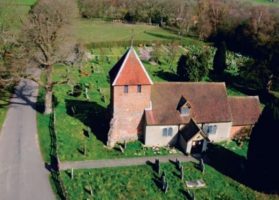
The Portway Roman road ran from Calleva Atrebatum (Silchester) to Old Sarum (near Salisbury) (shown on the above map). The 1:25,000 Ordnance Survey (OS) Explorer map, published 1998, shows the road crossing Pamber Forest from Calleva West Gate and passing south of St Peter’s Church before going onto Tadley Place and beyond. However, we did not know of any physical evidence of its route, despite having explored the area around St Peter’s Church and taking aerial photographs of the area as part of the hunt for Medieval Tadley.
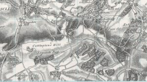
In trying to answer the question of the road’s route, maps do not offer a definitive answer. When one looks at the road as marked on the current OS Explorer 1:25,000 map there is small deviation (1.9 degrees) in the route at map ref SU552571. This is about half a mile to the south west of the A339 road and at the bottom of a valley, which is odd because we all know that the Romans sighted road lines from the tops of hills. It is 6.1 miles from Calleva. The route of the Portway is well known to the west of Hannington as it shows in the course of present day roads and bridleways. If the road from the west continued east as a straight line from Hannington, without the deviation, it arrives at the South Gate of Calleva.
The line of the Portway is marked on all OS maps since the 1890s with the route the same as today. However the earlier maps have the deviation point at an average position of SU575583, which is east of the A339 approx 3.3 miles from Calleva.
The Portway is not marked on the first OS map of the area (survey about 1808), but there are tracks showing its possible route running north east from the Hannington area to Fosse Cot. These are not shown on later maps.
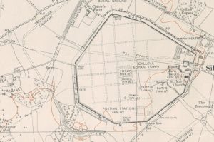
Another question is, exactly where does the Portway enter the Roman town? Old maps have it entering via the West Gate but modern ones and the map in Professor Michael Fulford’s official guide to Calleva have it entering via another gate 150 metres south of the West Gate. While this is of no great importance to Tadley, it could affect the line of the Portway’s route, and why would what must have been a major road leave by a minor gate?
So, is the route of the Portway shown by the Ordnance Survey accurate?
Other Roman roads in the Tadley area
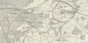
Early in 2020 it was noticed that on page 73 of Raymond West’s book, Pamber Heath History, there is a clip of a 1911 OS map showing the Pamber Road/Soke Road area and on it is marked a ‘ROMAN ROAD (From Silchester to Speen)’ crossing the top of Silchester Common and heading west through Pamber Heath.
Checking the OS 1 inch maps, the 1897/1900 map has it marked ‘Supposed ROMAN ROAD’, but the 1919/1920 map as just ‘ROMAN ROAD’.
All post World War II maps have it on a completely different route running north west from the Calleva West Gate through Benyon’s Inclosure and on to Speen via Thatcham.
Is this correct, or do we have another Roman road passing through Tadley?
What the Victorians said
An online search for information about the Portway in March 2017 revealed several useful links. Of these the most relevant was an extract from ‘Roman Roads in Britain’ by Thomas Codrington, first published in 1903. It describes all the known Roman roads and their existing remains. Chapter IX: Roman Roads from London to Silchester and the West, (section 4) Silchester to Old Sarum says:
‘This road, called the Portway, was supposed by Sir R. Colt Hoare to branch off from the Winchester road outside the south gate of Silchester, in the wood below the wall, where he says it was visible. A comparison of his map with that of Maclauchlan (1850) shows that the Roman roads of the former are ancient intrenchments in the latter. The new Ordnance map, on what authority does not appear, shows the road by a dotted line from the West Gate, through Pamber Forest, and by Tadley Place Farm to Foscot. Sir R. Colt Hoare failed to trace it, and Maclauchlan, in 1851 found not the least vestige of the road eastward of Foscot. There the tertiary beds are quitted, and on the chalk escarpment, six miles from Silchester, the ridge of the road is shown on the old Ordnance map for one and a half miles pointing towards the south side of Silchester, and in the opposite direction to high ground (700′) at Freemantle Park Farm, but it is now hardly traceable.’
This does not exactly endorse the OS route and there is suggestion that the Portway may have gone to the South Gate of Calleva, as does the true line from the west.
As a qualification of the Romans making roads in straight lines, Codrington finishes the section with:
‘A straight line from Silchester to Old Sarum passes a mile to the south of the Roman road at Quarley Hill, where the road lies farthest away from a straight line in the 36 miles between those places.’
Of the road from Calleva to Speen, Codrington Chapter IX, (section 10) Silchester to Speen, Bath, and South Wales says:
‘A road from Silchester to Speen (Spinae) appears in Iter XIII and in Iter XIV of Antonine. It issued from the west gate, and its course is indicated by a highway with a parish and county boundary for three and a half miles, beyond which there is little or no trace to Speen, where the roads branched.’
This may be interpreted as the Hampshire/Berkshire boundary through present day Pamber Heath in agreement with the OS maps of the time.
Codrington’s book was re-published in a revised edition in 1918 and seems to have been regarded as the definitive work of the period.
After World War II
In 1955 ‘Roman Roads in Britain: 1 South of the Fosse Way – Bristol Channel ‘ by Ivan D Margary was published. This book was an effort to improve on Codrington’s book using later work and route surveys of 6000 miles of roads conducted by the author.
The book has a very interesting introduction which is well worth reading. From this introduction a number of points are worth highlighting:
THE CHARACTERISTICS OF ROMAN ROADS
‘laying-out of the roads upon straight alignments’;
‘in general the alignments of the main roads were laid out with rigid accuracy for very long distances.’
‘it will be seen that very slight changes of line occur on intermediate hilltops, hardly sufficient to be noticeable as changes of direction,’
‘The alignment angles are very distinctive features, for the road follows each alignment right up to the angle, unlike the curving courses of later roads, and as the angle occurs upon a high point rigid straightness is not an invariable characteristic’;
‘the roads were laid upon a well-constructed embankment of varying height, in order to give them a properly drained base,’
‘The material for the embankment was generally derived from the excavation of a broad scoop-ditch along one or both sides of the road’;
‘The Roman name for the embankment was agger, and this short word is so convenient that it is still normally used in speaking of these roads.’
TRACING THE REMAINS OF THE ROADS
‘Most often the agger will then appear as a very slight broad ridge, hardly more than a gentle swelling in the ground;’
‘the road may have been removed, either for the sake of the stone which could be usefully employed elsewhere, or to clear the land for better cultivation’;
‘Hedgerow lines, sometimes of considerable length, and lanes or minor roads, with footpaths and tracks, often mark parts of the course and are very significant if a long line of them can be traced across country’;
‘in forest areas upon soft soil, the road will be entirely invisible, —–. Experience has shown that it may have survived with its metalled surface quite intact but entirely buried.’
The bulk of the book is a gazeteer of each identified Roman road.
Of the Portway Ivan Margary says:
At the west gate of Silchester (Calleva Atrebatum) the western route forked, northwestward to Speen and Gloucester (41) with a branch to Bath (53), and southwestward to Old Sarum and the west. At first this route is obscured by the large excavation of the Flex Ditch, and then it traverses Pamber Forest where little can be seen, though at the western exit from this wood, at Tadley, a piece of the agger can be traced just south of the present track and inside the wood. After crossing the main road at Tadley it is, however, plainly visible as a large agger running from the stream at Honey Mill Bridge up to Skate’s Farm, whose buildings stand across the line. It is said that the line can be seen in the crops west of the farm parallel with the hedgerow a few yards south of it. Some faint traces mark the line north of Stony Heath, but little can be seen till the high downs near Fremantle Park Farm are reached. This point, 7.5 miles from Silchester, was evidently a main sighting mark, for the alignment changes very slightly more to the west near here. A really magnificent vista of the route now opens up to the south-west past Walkeridge Farm, first along a lane which is generally on or slightly north of the agger and then by a line of hedgerows for 4.5 – miles to Clap Gate, where the Newbury-Winchester railway is crossed.’
This is the route of the road as indicated on the modern OS maps, except that the deviation angle for the last few miles to Calleva is made at the top of a hill near Hannington, approximately half a mile south east of the TV tower.This makes far more sense than the deviation being at a point in a valley. In fact the deviation angle is so small that shifting its position one way or another would make very little difference to the actual line of the road.
In the area of Honeymill Bridge, Tadley and Skates Farm the agger can be seen in places. Also one of the cottages on the Pamber Forest side of the A340 is called Portway Cottage. There is also a cutting on the line of the road near to St Peter’s Church.
Of the road to Speen from Calleva Ivan Margary says:
‘The western trunk road from London forked at Silchester (Calleva Atrebatum), and from the west gate of the town two important routes diverged, south-westward to Dorchester and Exeter and north-westward to the legionary fortress at Gloucester which, as the main centre for operations against the Britons in South Wales, was a Roman town of great importance. Both these roads must have been constructed at a very early stage of the occupation. Beyond Speen, near Newbury, this road bears the traditional name Ermin Street and is still a main road for the most part, but this first section had been completely lost and has only recently been rediscovered. Thus for some time its course was supposed to have run due west along the county boundary, over Tadley Common and Crookham Common, to enter Newbury from the south, and this course is still marked on some maps. Support was lent to it by the find of a stone bearing the letters IMP, and hence called the Imp Stone, on Silchester Common close to this route, which it was thought might be the remaining part of a dedicatory inscription upon a milestone. It is indeed possible that a ridgeway track led this way to Newbury, but the aligned Roman road has now been definitely traced north-westward. The first alignment runs from Silchester, through Aldermaston Park to Thatcham, where the river Kennet was crossed, and is very rigidly followed throughout. The agger is visible, 3 feet high, through The Frith woods north of Silchester Common, and again on leaving the woods, where it rejoins the present road at Aldermaston Soke for a short distance. It was formerly visible in Keyser’s Plantation just before entering Aldermaston Park, but this area has suffered greatly from wartime disturbance and cannot now be examined. Its course embays one of the Park ponds, then some hedgerows mark it near Wasing, and the agger is traceable in Wasing Park. The gravel bedding of the road just before reaching the flood-plain of the Kennet near Quaking Bridge was identified in 1915.
Thus it is clear that the road to Speen is considered to run on the Northwest route but he still leaves open the possibility that there was another road or track going past Pamber Heath.
Close examination of the current OS 1:25,000 Explorer map indicates that sections of the agger are visible in the woods of Benyon’s Enclosure.
NB, from other research, Ivan Margary’s book still seems to be accepted as the definitive guide to the routes of Roman roads in Britain. It was republished in 1973.
Modern techniques
LiDAR (Light Detection and Ranging) is a remote sensing method that uses light in the form of a pulsed laser to examine the surface of the Earth. A powerful tool for aerial mapping, it has become widely used in recent years, showing detailed ground contours even in wooded areas. LiDAR imaging is available from websites for free.
The LiDAR mapping which TADS found was inconclusive, but Alex Flahive (a former TADS Project Group member) sent us some composite LiDAR scans of the area taken at different viewing angles and some of these clearly show the route of the Portway across Pamber Forest and on through Skates Farm.
Alex also sent a number of photographs, including some showing a cross section of the Roman road when it had been exposed by a trench cut near Skates Farm.
Conclusions
There is now no doubt that the Portway is near enough on the line shown on the current OS maps although its deviation for the last few miles to Calleva is almost certainly at the top of the ridge by Hannington.
Its final destination at Calleva is not certain as it is difficult to accept that a major highway entered the town by a minor gate, not the West Gate. Examination of the remaining wall in 2021 does not reveal any signs of there being or having been a small or minor gate to the south of the West Gate. Nor is there any sign of a breach or bridge to the nearby defensive ditch.
The Roman road from Calleva to Speen is also as marked on OS maps. However, there is still a possibility of another road running west through what is now Pamber Heath.
Richard Brown [TADS Project Group]
30 September 2022